You are here: Home > Network List > II - Global Seismograph Network (GSN - IRIS/IDA) Stations List
> Station PFO Pinon Flat, California, USA > Earthquake Result Viewer
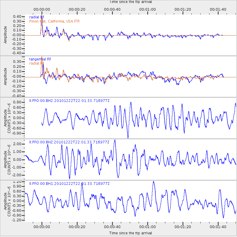
PFO Pinon Flat, California, USA - Earthquake Result Viewer
*The percent match for this event was below the threshold and hence no stack was calculated.
| Earthquake location: |
Bonin Islands, Japan Region |
| Earthquake latitude/longitude: |
26.8/143.6 |
| Earthquake time(UTC): |
2010/12/22 (356) 21:49:40 GMT |
| Earthquake Depth: |
18 km |
| Earthquake Magnitude: |
6.4 MW, 6.2 MB, 6.2 MW, 6.3 MS |
| Earthquake Catalog/Contributor: |
NEIC PDE/NEIC PDE-M |
|
| Network: |
II Global Seismograph Network (GSN - IRIS/IDA) |
| Station: |
PFO Pinon Flat, California, USA |
| Lat/Lon: |
33.61 N/116.46 W |
| Elevation: |
1280 m |
|
| Distance: |
83.2 deg |
| Az: |
55.872 deg |
| Baz: |
297.563 deg |
| Ray Param: |
$rayparam |
*The percent match for this event was below the threshold and hence was not used in the summary stack. |
|
| Radial Match: |
69.55523 % |
| Radial Bump: |
400 |
| Transverse Match: |
51.81622 % |
| Transverse Bump: |
400 |
| SOD ConfigId: |
617450 |
| Insert Time: |
2013-10-01 16:02:03.631 +0000 |
| GWidth: |
2.5 |
| Max Bumps: |
400 |
| Tol: |
0.001 |
|
Signal To Noise
| Channel | StoN | STA | LTA |
| II:PFO:00:BHZ:20101222T22:01:33.718977Z | 1.7514805 | 8.997081E-7 | 5.136843E-7 |
| II:PFO:00:BH1:20101222T22:01:33.718977Z | 0.5693887 | 3.0689856E-7 | 5.389966E-7 |
| II:PFO:00:BH2:20101222T22:01:33.718977Z | 1.0611844 | 2.6721997E-7 | 2.5181293E-7 |
| Arrivals |
| Ps | |
| PpPs | |
| PsPs/PpSs | |


