AAK Ala Archa, Kyrgyzstan - Earthquake Result Viewer
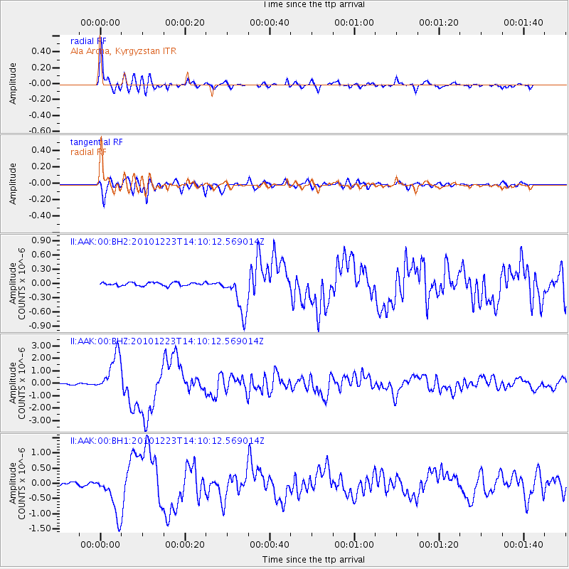
Earthquake location: Near Islands, Aleutian Islands
Earthquake latitude/longitude: 53.1/171.2
Earthquake time(UTC): 2010/12/23 (357) 14:00:32 GMT
Earthquake Depth: 18 km
Earthquake Magnitude: 6.4 MW, 6.1 MB, 6.3 MS, 6.3 MW
Earthquake Catalog/Contributor: NEIC PDE/NEIC PDE-M
Network: II Global Seismograph Network (GSN - IRIS/IDA)
Station: AAK Ala Archa, Kyrgyzstan
Lat/Lon: 42.64 N/74.49 E
Elevation: 1645 m
Distance: 60.9 deg
Az: 302.952 deg
Baz: 43.259 deg
Ray Param: 0.061236404
Estimated Moho Depth: 51.5 km
Estimated Crust Vp/Vs: 1.69
Assumed Crust Vp: 6.306 km/s
Estimated Crust Vs: 3.737 km/s
Estimated Crust Poisson's Ratio: 0.23
Radial Match: 95.812904 %
Radial Bump: 400
Transverse Match: 95.4782 %
Transverse Bump: 400
SOD ConfigId: 617450
Insert Time: 2013-10-01 16:03:53.659 +0000
GWidth: 2.5
Max Bumps: 400
Tol: 0.001

Signal To Noise

ChannelStoNSTALTA
II:AAK:00:BHZ:20101223T14:10:12.569014Z42.249091.6336817E-63.8667856E-8
II:AAK:00:BH1:20101223T14:10:12.569014Z17.7891437.018712E-73.945503E-8
II:AAK:00:BH2:20101223T14:10:12.569014Z12.8340284.3620628E-73.3988258E-8
Arrivals
Ps5.9 SECOND
PpPs21 SECOND
PsPs/PpSs27 SECOND