You are here: Home > Network List > II - Global Seismograph Network (GSN - IRIS/IDA) Stations List
> Station PFO Pinon Flat, California, USA > Earthquake Result Viewer
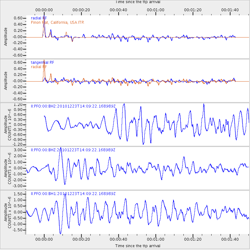
PFO Pinon Flat, California, USA - Earthquake Result Viewer
*The percent match for this event was below the threshold and hence no stack was calculated.
| Earthquake location: |
Near Islands, Aleutian Islands |
| Earthquake latitude/longitude: |
53.1/171.2 |
| Earthquake time(UTC): |
2010/12/23 (357) 14:00:32 GMT |
| Earthquake Depth: |
18 km |
| Earthquake Magnitude: |
6.4 MW, 6.1 MB, 6.3 MS, 6.3 MW |
| Earthquake Catalog/Contributor: |
NEIC PDE/NEIC PDE-M |
|
| Network: |
II Global Seismograph Network (GSN - IRIS/IDA) |
| Station: |
PFO Pinon Flat, California, USA |
| Lat/Lon: |
33.61 N/116.46 W |
| Elevation: |
1280 m |
|
| Distance: |
53.7 deg |
| Az: |
80.684 deg |
| Baz: |
314.554 deg |
| Ray Param: |
$rayparam |
*The percent match for this event was below the threshold and hence was not used in the summary stack. |
|
| Radial Match: |
79.017845 % |
| Radial Bump: |
300 |
| Transverse Match: |
63.54856 % |
| Transverse Bump: |
400 |
| SOD ConfigId: |
617450 |
| Insert Time: |
2013-10-01 16:04:09.334 +0000 |
| GWidth: |
2.5 |
| Max Bumps: |
400 |
| Tol: |
0.001 |
|
Signal To Noise
| Channel | StoN | STA | LTA |
| II:PFO:00:BHZ:20101223T14:09:22.168989Z | 0.8963084 | 4.5203996E-7 | 5.043353E-7 |
| II:PFO:00:BH1:20101223T14:09:22.168989Z | 1.7570466 | 3.3445042E-7 | 1.9034806E-7 |
| II:PFO:00:BH2:20101223T14:09:22.168989Z | 1.5211701 | 3.1711966E-7 | 2.0847087E-7 |
| Arrivals |
| Ps | |
| PpPs | |
| PsPs/PpSs | |


