You are here: Home > Network List > IU - Global Seismograph Network (GSN - IRIS/USGS) Stations List
> Station TEIG Tepich, Yucatan, Mexico > Earthquake Result Viewer
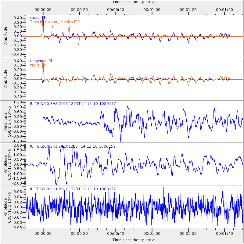
TEIG Tepich, Yucatan, Mexico - Earthquake Result Viewer
*The percent match for this event was below the threshold and hence no stack was calculated.
| Earthquake location: |
Near Islands, Aleutian Islands |
| Earthquake latitude/longitude: |
53.1/171.2 |
| Earthquake time(UTC): |
2010/12/23 (357) 14:00:32 GMT |
| Earthquake Depth: |
18 km |
| Earthquake Magnitude: |
6.4 MW, 6.1 MB, 6.3 MS, 6.3 MW |
| Earthquake Catalog/Contributor: |
NEIC PDE/NEIC PDE-M |
|
| Network: |
IU Global Seismograph Network (GSN - IRIS/USGS) |
| Station: |
TEIG Tepich, Yucatan, Mexico |
| Lat/Lon: |
20.23 N/88.28 W |
| Elevation: |
40 m |
|
| Distance: |
80.2 deg |
| Az: |
69.536 deg |
| Baz: |
323.043 deg |
| Ray Param: |
$rayparam |
*The percent match for this event was below the threshold and hence was not used in the summary stack. |
|
| Radial Match: |
76.51484 % |
| Radial Bump: |
400 |
| Transverse Match: |
73.48698 % |
| Transverse Bump: |
400 |
| SOD ConfigId: |
617450 |
| Insert Time: |
2013-10-01 16:04:41.054 +0000 |
| GWidth: |
2.5 |
| Max Bumps: |
400 |
| Tol: |
0.001 |
|
Signal To Noise
| Channel | StoN | STA | LTA |
| IU:TEIG:00:BHZ:20101223T14:12:10.108015Z | 6.19529 | 7.1913524E-7 | 1.1607773E-7 |
| IU:TEIG:00:BH1:20101223T14:12:10.108015Z | 0.93364376 | 2.291653E-8 | 2.4545262E-8 |
| IU:TEIG:00:BH2:20101223T14:12:10.108015Z | 2.0732477 | 2.8140678E-7 | 1.3573236E-7 |
| Arrivals |
| Ps | |
| PpPs | |
| PsPs/PpSs | |


