You are here: Home > Network List > II - Global Seismograph Network (GSN - IRIS/IDA) Stations List
> Station ABPO Ambohimpanompo, Madagascar > Earthquake Result Viewer
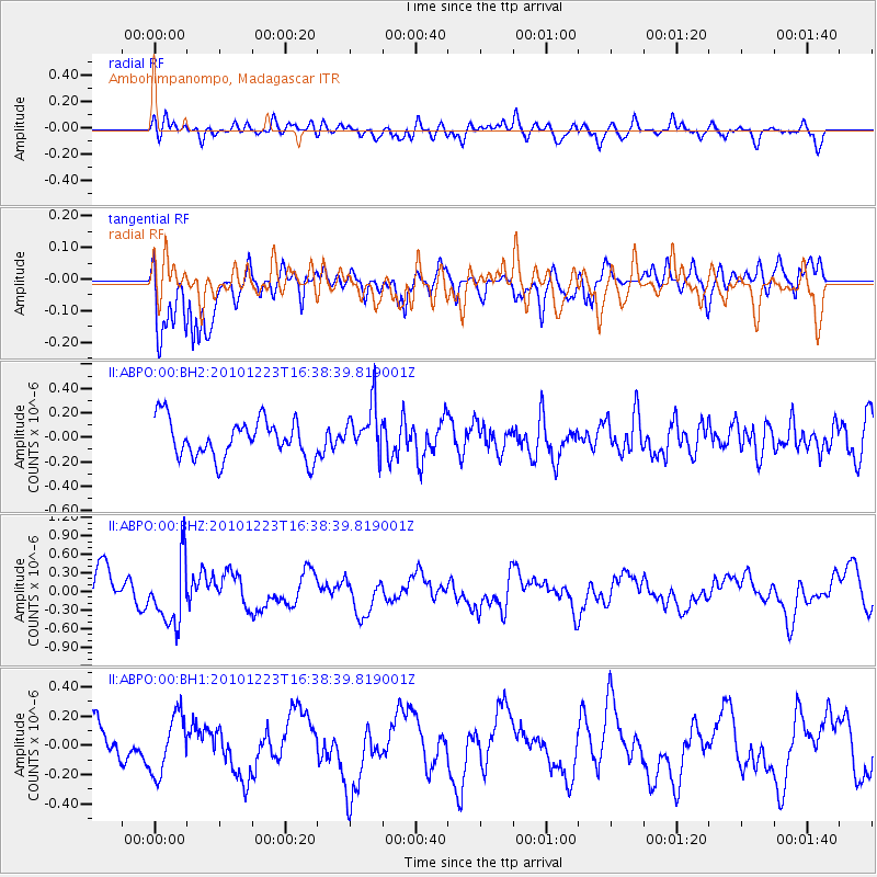
ABPO Ambohimpanompo, Madagascar - Earthquake Result Viewer
*The percent match for this event was below the threshold and hence no stack was calculated.
| Earthquake location: |
Flores Sea |
| Earthquake latitude/longitude: |
-8.0/120.0 |
| Earthquake time(UTC): |
2010/12/23 (357) 16:28:14 GMT |
| Earthquake Depth: |
207 km |
| Earthquake Magnitude: |
5.5 MB, 5.5 MW |
| Earthquake Catalog/Contributor: |
WHDF/NEIC |
|
| Network: |
II Global Seismograph Network (GSN - IRIS/IDA) |
| Station: |
ABPO Ambohimpanompo, Madagascar |
| Lat/Lon: |
19.02 S/47.23 E |
| Elevation: |
1528 m |
|
| Distance: |
71.2 deg |
| Az: |
252.666 deg |
| Baz: |
92.15 deg |
| Ray Param: |
$rayparam |
*The percent match for this event was below the threshold and hence was not used in the summary stack. |
|
| Radial Match: |
55.970016 % |
| Radial Bump: |
400 |
| Transverse Match: |
80.016945 % |
| Transverse Bump: |
400 |
| SOD ConfigId: |
617450 |
| Insert Time: |
2013-10-01 16:07:32.314 +0000 |
| GWidth: |
2.5 |
| Max Bumps: |
400 |
| Tol: |
0.001 |
|
Signal To Noise
| Channel | StoN | STA | LTA |
| II:ABPO:00:BHZ:20101223T16:38:39.819001Z | 1.9647256 | 5.2729405E-7 | 2.683805E-7 |
| II:ABPO:00:BH1:20101223T16:38:39.819001Z | 1.5068492 | 2.000959E-7 | 1.3279093E-7 |
| II:ABPO:00:BH2:20101223T16:38:39.819001Z | 1.3057582 | 2.0434658E-7 | 1.5649648E-7 |
| Arrivals |
| Ps | |
| PpPs | |
| PsPs/PpSs | |


