You are here: Home > Network List > IU - Global Seismograph Network (GSN - IRIS/USGS) Stations List
> Station HNR Honiara, Solomon Islands > Earthquake Result Viewer
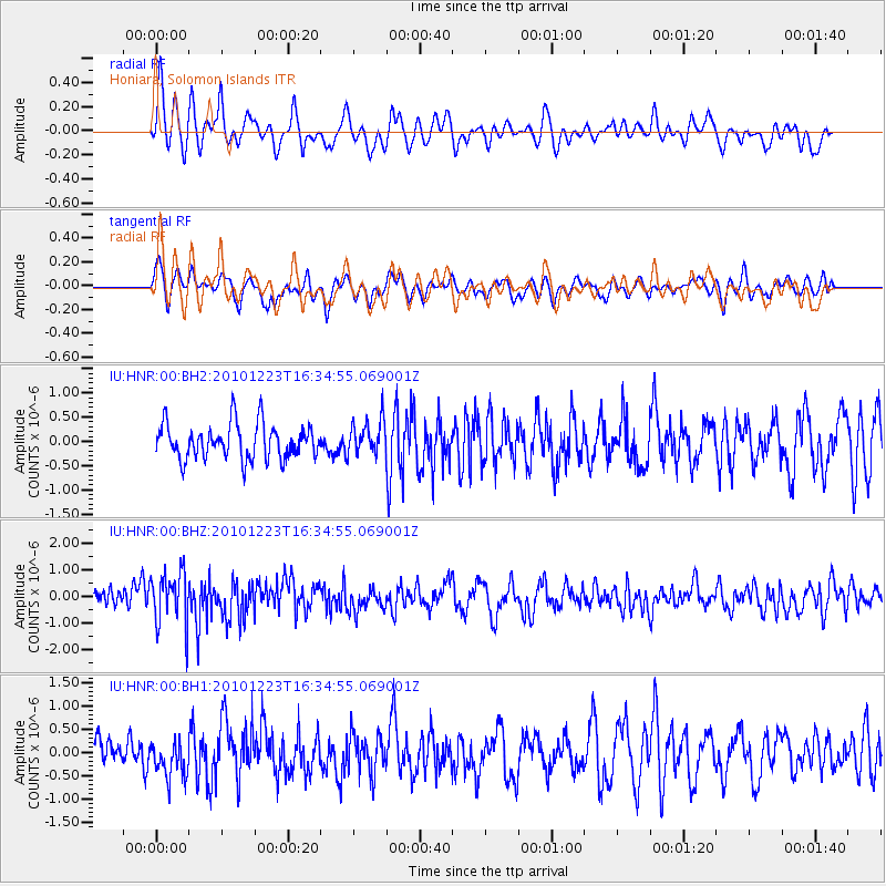
HNR Honiara, Solomon Islands - Earthquake Result Viewer
*The percent match for this event was below the threshold and hence no stack was calculated.
| Earthquake location: |
Flores Sea |
| Earthquake latitude/longitude: |
-8.0/120.0 |
| Earthquake time(UTC): |
2010/12/23 (357) 16:28:14 GMT |
| Earthquake Depth: |
207 km |
| Earthquake Magnitude: |
5.5 MB, 5.5 MW |
| Earthquake Catalog/Contributor: |
WHDF/NEIC |
|
| Network: |
IU Global Seismograph Network (GSN - IRIS/USGS) |
| Station: |
HNR Honiara, Solomon Islands |
| Lat/Lon: |
9.44 S/159.95 E |
| Elevation: |
100 m |
|
| Distance: |
39.5 deg |
| Az: |
95.124 deg |
| Baz: |
268.85 deg |
| Ray Param: |
$rayparam |
*The percent match for this event was below the threshold and hence was not used in the summary stack. |
|
| Radial Match: |
64.5829 % |
| Radial Bump: |
400 |
| Transverse Match: |
64.8138 % |
| Transverse Bump: |
400 |
| SOD ConfigId: |
617450 |
| Insert Time: |
2013-10-01 16:07:48.451 +0000 |
| GWidth: |
2.5 |
| Max Bumps: |
400 |
| Tol: |
0.001 |
|
Signal To Noise
| Channel | StoN | STA | LTA |
| IU:HNR:00:BHZ:20101223T16:34:55.069001Z | 3.102686 | 9.864057E-7 | 3.179199E-7 |
| IU:HNR:00:BH1:20101223T16:34:55.069001Z | 1.2914728 | 4.0759804E-7 | 3.1560714E-7 |
| IU:HNR:00:BH2:20101223T16:34:55.069001Z | 0.9907295 | 3.5998858E-7 | 3.6335706E-7 |
| Arrivals |
| Ps | |
| PpPs | |
| PsPs/PpSs | |


