You are here: Home > Network List > II - Global Seismograph Network (GSN - IRIS/IDA) Stations List
> Station WRAB Tennant Creek, NT, Australia > Earthquake Result Viewer
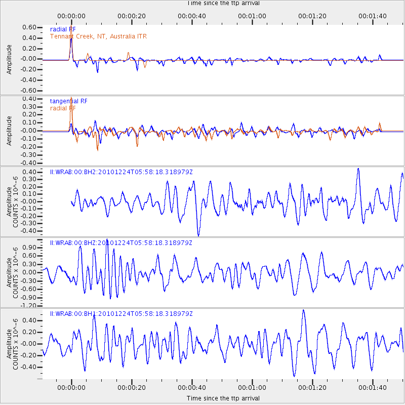
WRAB Tennant Creek, NT, Australia - Earthquake Result Viewer
*The percent match for this event was below the threshold and hence no stack was calculated.
| Earthquake location: |
Pacific-Antarctic Ridge |
| Earthquake latitude/longitude: |
-63.6/-167.4 |
| Earthquake time(UTC): |
2010/12/24 (358) 05:48:52 GMT |
| Earthquake Depth: |
4.0 km |
| Earthquake Magnitude: |
5.9 MW, 5.8 MB, 5.9 MS, 5.9 MW |
| Earthquake Catalog/Contributor: |
NEIC PDE/NEIC PDE-M |
|
| Network: |
II Global Seismograph Network (GSN - IRIS/IDA) |
| Station: |
WRAB Tennant Creek, NT, Australia |
| Lat/Lon: |
19.93 S/134.36 E |
| Elevation: |
366 m |
|
| Distance: |
58.4 deg |
| Az: |
289.97 deg |
| Baz: |
153.467 deg |
| Ray Param: |
$rayparam |
*The percent match for this event was below the threshold and hence was not used in the summary stack. |
|
| Radial Match: |
73.49375 % |
| Radial Bump: |
279 |
| Transverse Match: |
53.03162 % |
| Transverse Bump: |
400 |
| SOD ConfigId: |
617450 |
| Insert Time: |
2013-10-01 16:09:16.464 +0000 |
| GWidth: |
2.5 |
| Max Bumps: |
400 |
| Tol: |
0.001 |
|
Signal To Noise
| Channel | StoN | STA | LTA |
| II:WRAB:00:BHZ:20101224T05:58:18.318979Z | 2.9213064 | 4.890581E-7 | 1.6741075E-7 |
| II:WRAB:00:BH1:20101224T05:58:18.318979Z | 1.521445 | 2.0688768E-7 | 1.3598104E-7 |
| II:WRAB:00:BH2:20101224T05:58:18.318979Z | 2.136694 | 1.526262E-7 | 7.143101E-8 |
| Arrivals |
| Ps | |
| PpPs | |
| PsPs/PpSs | |


