You are here: Home > Network List > II - Global Seismograph Network (GSN - IRIS/IDA) Stations List
> Station WRAB Tennant Creek, NT, Australia > Earthquake Result Viewer
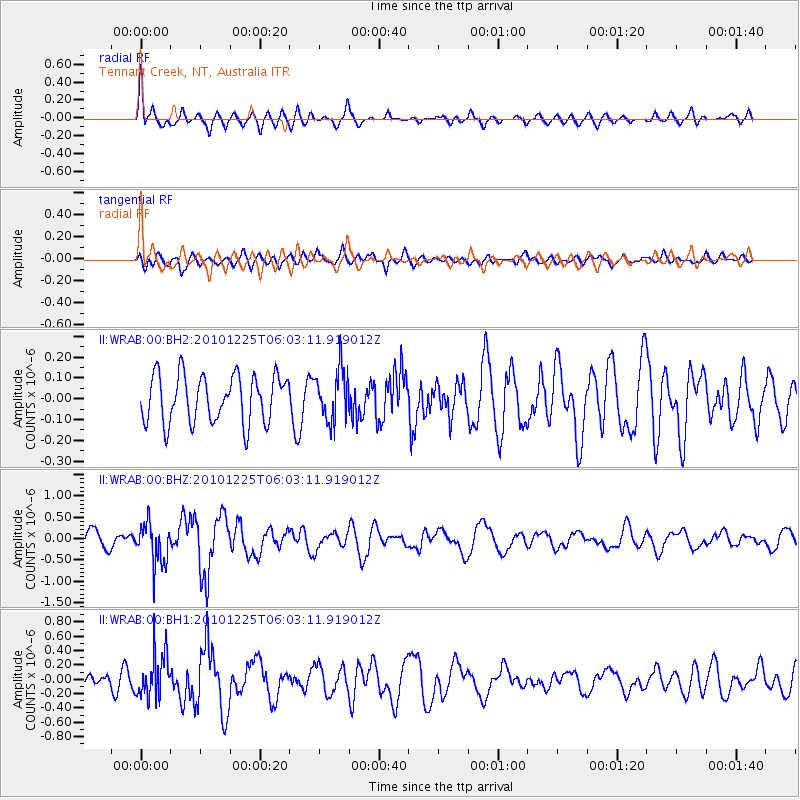
WRAB Tennant Creek, NT, Australia - Earthquake Result Viewer
*The percent match for this event was below the threshold and hence no stack was calculated.
| Earthquake location: |
Volcano Islands, Japan Region |
| Earthquake latitude/longitude: |
25.5/141.1 |
| Earthquake time(UTC): |
2010/12/25 (359) 05:55:23 GMT |
| Earthquake Depth: |
20 km |
| Earthquake Magnitude: |
5.5 MB |
| Earthquake Catalog/Contributor: |
NEIC PDE/NEIC PDE-M |
|
| Network: |
II Global Seismograph Network (GSN - IRIS/IDA) |
| Station: |
WRAB Tennant Creek, NT, Australia |
| Lat/Lon: |
19.93 S/134.36 E |
| Elevation: |
366 m |
|
| Distance: |
45.7 deg |
| Az: |
188.909 deg |
| Baz: |
8.553 deg |
| Ray Param: |
$rayparam |
*The percent match for this event was below the threshold and hence was not used in the summary stack. |
|
| Radial Match: |
79.53274 % |
| Radial Bump: |
400 |
| Transverse Match: |
59.59343 % |
| Transverse Bump: |
400 |
| SOD ConfigId: |
617450 |
| Insert Time: |
2013-10-01 16:10:40.184 +0000 |
| GWidth: |
2.5 |
| Max Bumps: |
400 |
| Tol: |
0.001 |
|
Signal To Noise
| Channel | StoN | STA | LTA |
| II:WRAB:00:BHZ:20101225T06:03:11.919012Z | 2.322773 | 4.7447148E-7 | 2.0426941E-7 |
| II:WRAB:00:BH1:20101225T06:03:11.919012Z | 3.1784725 | 3.0824822E-7 | 9.697998E-8 |
| II:WRAB:00:BH2:20101225T06:03:11.919012Z | 1.0707334 | 1.2212435E-7 | 1.1405673E-7 |
| Arrivals |
| Ps | |
| PpPs | |
| PsPs/PpSs | |


