You are here: Home > Network List > II - Global Seismograph Network (GSN - IRIS/IDA) Stations List
> Station WRAB Tennant Creek, NT, Australia > Earthquake Result Viewer
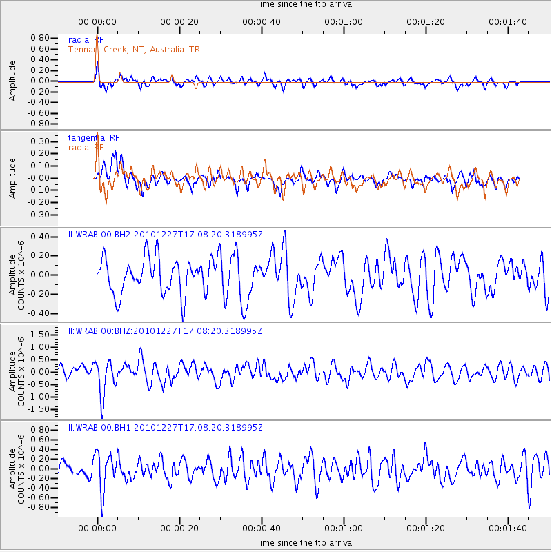
WRAB Tennant Creek, NT, Australia - Earthquake Result Viewer
*The percent match for this event was below the threshold and hence no stack was calculated.
| Earthquake location: |
Western Indian-Antarctic Ridge |
| Earthquake latitude/longitude: |
-50.8/139.4 |
| Earthquake time(UTC): |
2010/12/27 (361) 17:02:32 GMT |
| Earthquake Depth: |
10 km |
| Earthquake Magnitude: |
5.6 MW, 5.5 MB |
| Earthquake Catalog/Contributor: |
NEIC PDE/NEIC PDE-M |
|
| Network: |
II Global Seismograph Network (GSN - IRIS/IDA) |
| Station: |
WRAB Tennant Creek, NT, Australia |
| Lat/Lon: |
19.93 S/134.36 E |
| Elevation: |
366 m |
|
| Distance: |
31.1 deg |
| Az: |
350.829 deg |
| Baz: |
173.83 deg |
| Ray Param: |
$rayparam |
*The percent match for this event was below the threshold and hence was not used in the summary stack. |
|
| Radial Match: |
61.955425 % |
| Radial Bump: |
400 |
| Transverse Match: |
56.95455 % |
| Transverse Bump: |
376 |
| SOD ConfigId: |
617450 |
| Insert Time: |
2013-10-01 16:21:29.593 +0000 |
| GWidth: |
2.5 |
| Max Bumps: |
400 |
| Tol: |
0.001 |
|
Signal To Noise
| Channel | StoN | STA | LTA |
| II:WRAB:00:BHZ:20101227T17:08:20.318995Z | 3.292815 | 7.184849E-7 | 2.1819778E-7 |
| II:WRAB:00:BH1:20101227T17:08:20.318995Z | 2.693307 | 3.9336743E-7 | 1.4605371E-7 |
| II:WRAB:00:BH2:20101227T17:08:20.318995Z | 1.2658938 | 2.3297744E-7 | 1.8404187E-7 |
| Arrivals |
| Ps | |
| PpPs | |
| PsPs/PpSs | |


