You are here: Home > Network List > II - Global Seismograph Network (GSN - IRIS/IDA) Stations List
> Station KAPI Kappang, Sulawesi, Indonesia > Earthquake Result Viewer
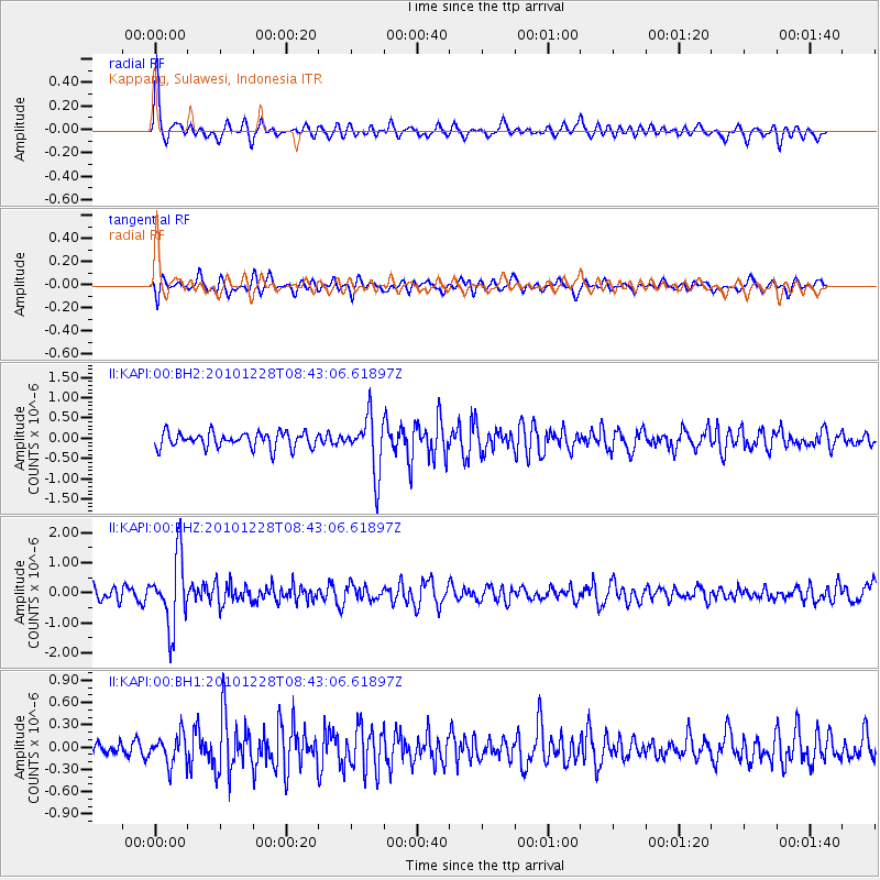
KAPI Kappang, Sulawesi, Indonesia - Earthquake Result Viewer
*The percent match for this event was below the threshold and hence no stack was calculated.
| Earthquake location: |
South Of Fiji Islands |
| Earthquake latitude/longitude: |
-23.4/-179.8 |
| Earthquake time(UTC): |
2010/12/28 (362) 08:34:17 GMT |
| Earthquake Depth: |
551 km |
| Earthquake Magnitude: |
6.3 MW, 5.7 MB, 6.3 MW |
| Earthquake Catalog/Contributor: |
NEIC PDE/NEIC PDE-M |
|
| Network: |
II Global Seismograph Network (GSN - IRIS/IDA) |
| Station: |
KAPI Kappang, Sulawesi, Indonesia |
| Lat/Lon: |
5.01 S/119.75 E |
| Elevation: |
300 m |
|
| Distance: |
60.9 deg |
| Az: |
277.516 deg |
| Baz: |
113.903 deg |
| Ray Param: |
$rayparam |
*The percent match for this event was below the threshold and hence was not used in the summary stack. |
|
| Radial Match: |
71.35915 % |
| Radial Bump: |
379 |
| Transverse Match: |
57.373135 % |
| Transverse Bump: |
400 |
| SOD ConfigId: |
617450 |
| Insert Time: |
2013-10-01 16:25:47.628 +0000 |
| GWidth: |
2.5 |
| Max Bumps: |
400 |
| Tol: |
0.001 |
|
Signal To Noise
| Channel | StoN | STA | LTA |
| II:KAPI:00:BHZ:20101228T08:43:06.61897Z | 5.698352 | 1.1459862E-6 | 2.0110834E-7 |
| II:KAPI:00:BH1:20101228T08:43:06.61897Z | 1.3343016 | 2.008304E-7 | 1.505135E-7 |
| II:KAPI:00:BH2:20101228T08:43:06.61897Z | 3.6163168 | 6.8739394E-7 | 1.9008121E-7 |
| Arrivals |
| Ps | |
| PpPs | |
| PsPs/PpSs | |


