You are here: Home > Network List > IU - Global Seismograph Network (GSN - IRIS/USGS) Stations List
> Station JOHN Johnston Island, USA > Earthquake Result Viewer
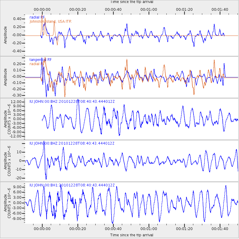
JOHN Johnston Island, USA - Earthquake Result Viewer
*The percent match for this event was below the threshold and hence no stack was calculated.
| Earthquake location: |
South Of Fiji Islands |
| Earthquake latitude/longitude: |
-23.4/-179.8 |
| Earthquake time(UTC): |
2010/12/28 (362) 08:34:17 GMT |
| Earthquake Depth: |
551 km |
| Earthquake Magnitude: |
6.3 MW, 5.7 MB, 6.3 MW |
| Earthquake Catalog/Contributor: |
NEIC PDE/NEIC PDE-M |
|
| Network: |
IU Global Seismograph Network (GSN - IRIS/USGS) |
| Station: |
JOHN Johnston Island, USA |
| Lat/Lon: |
16.73 N/169.53 W |
| Elevation: |
2.0 m |
|
| Distance: |
41.1 deg |
| Az: |
15.055 deg |
| Baz: |
194.42 deg |
| Ray Param: |
$rayparam |
*The percent match for this event was below the threshold and hence was not used in the summary stack. |
|
| Radial Match: |
57.49584 % |
| Radial Bump: |
338 |
| Transverse Match: |
54.56945 % |
| Transverse Bump: |
400 |
| SOD ConfigId: |
617450 |
| Insert Time: |
2013-10-01 16:26:00.002 +0000 |
| GWidth: |
2.5 |
| Max Bumps: |
400 |
| Tol: |
0.001 |
|
Signal To Noise
| Channel | StoN | STA | LTA |
| IU:JOHN:00:BHZ:20101228T08:40:43.444012Z | 4.360046 | 1.0880227E-5 | 2.4954386E-6 |
| IU:JOHN:00:BH1:20101228T08:40:43.444012Z | 1.6106786 | 5.1229586E-6 | 3.1806214E-6 |
| IU:JOHN:00:BH2:20101228T08:40:43.444012Z | 1.1390558 | 5.713744E-6 | 5.0162107E-6 |
| Arrivals |
| Ps | |
| PpPs | |
| PsPs/PpSs | |


