You are here: Home > Network List > II - Global Seismograph Network (GSN - IRIS/IDA) Stations List
> Station KAPI Kappang, Sulawesi, Indonesia > Earthquake Result Viewer
KAPI Kappang, Sulawesi, Indonesia - Earthquake Result Viewer
| Earthquake location: |
Vanuatu Islands |
| Earthquake latitude/longitude: |
-19.7/168.1 |
| Earthquake time(UTC): |
2010/12/29 (363) 06:54:19 GMT |
| Earthquake Depth: |
16 km |
| Earthquake Magnitude: |
6.3 MW, 6.2 MB, 6.2 MS, 6.4 MW |
| Earthquake Catalog/Contributor: |
NEIC PDE/NEIC PDE-M |
|
| Network: |
II Global Seismograph Network (GSN - IRIS/IDA) |
| Station: |
KAPI Kappang, Sulawesi, Indonesia |
| Lat/Lon: |
5.01 S/119.75 E |
| Elevation: |
300 m |
|
| Distance: |
49.3 deg |
| Az: |
280.604 deg |
| Baz: |
111.592 deg |
| Ray Param: |
0.068792924 |
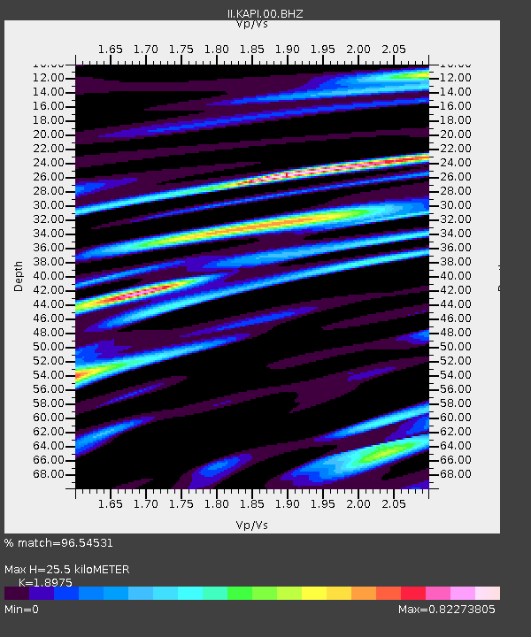
| Estimated Moho Depth: |
25.5 km |
| Estimated Crust Vp/Vs: |
1.90 |
| Assumed Crust Vp: |
6.343 km/s |
| Estimated Crust Vs: |
3.343 km/s |
| Estimated Crust Poisson's Ratio: |
0.31 |
|
| Radial Match: |
96.54531 % |
| Radial Bump: |
400 |
| Transverse Match: |
91.35945 % |
| Transverse Bump: |
400 |
| SOD ConfigId: |
617450 |
| Insert Time: |
2013-10-01 16:28:02.358 +0000 |
| GWidth: |
2.5 |
| Max Bumps: |
400 |
| Tol: |
0.001 |
|

Signal To Noise
| Channel | StoN | STA | LTA |
| II:KAPI:00:BHZ:20101229T07:02:36.568986Z | 26.566498 | 1.9806162E-6 | 7.455316E-8 |
| II:KAPI:00:BH1:20101229T07:02:36.568986Z | 4.4147353 | 3.642032E-7 | 8.249718E-8 |
| II:KAPI:00:BH2:20101229T07:02:36.568986Z | 11.570124 | 1.1103011E-6 | 9.5962776E-8 |
| Arrivals |
| Ps | 3.8 SECOND |
| PpPs | 11 SECOND |
| PsPs/PpSs | 15 SECOND |


