You are here: Home > Network List > IU - Global Seismograph Network (GSN - IRIS/USGS) Stations List
> Station MAKZ Makanchi, Kazakhstan > Earthquake Result Viewer
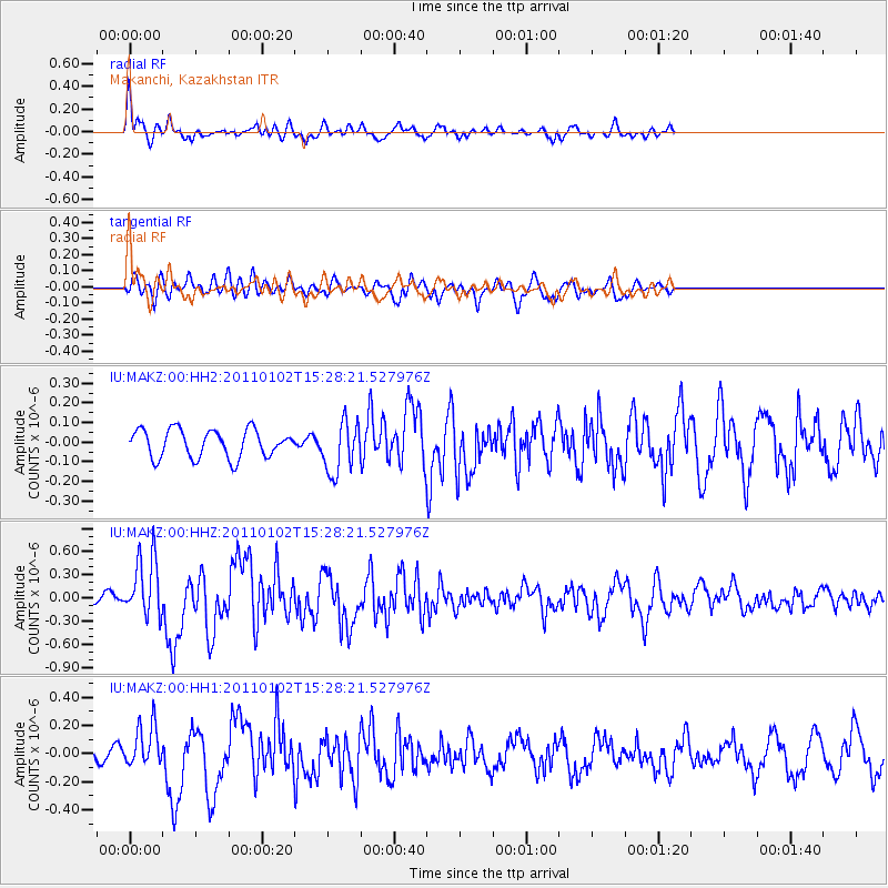
MAKZ Makanchi, Kazakhstan - Earthquake Result Viewer
*The percent match for this event was below the threshold and hence no stack was calculated.
| Earthquake location: |
Southern Sumatra, Indonesia |
| Earthquake latitude/longitude: |
-4.5/101.4 |
| Earthquake time(UTC): |
2011/01/02 (002) 15:19:31 GMT |
| Earthquake Depth: |
22 km |
| Earthquake Magnitude: |
5.7 MB, 5.6 MS, 5.8 MW, 5.7 MW |
| Earthquake Catalog/Contributor: |
WHDF/NEIC |
|
| Network: |
IU Global Seismograph Network (GSN - IRIS/USGS) |
| Station: |
MAKZ Makanchi, Kazakhstan |
| Lat/Lon: |
46.81 N/81.98 E |
| Elevation: |
600 m |
|
| Distance: |
53.9 deg |
| Az: |
343.549 deg |
| Baz: |
155.728 deg |
| Ray Param: |
$rayparam |
*The percent match for this event was below the threshold and hence was not used in the summary stack. |
|
| Radial Match: |
76.77175 % |
| Radial Bump: |
323 |
| Transverse Match: |
66.60409 % |
| Transverse Bump: |
400 |
| SOD ConfigId: |
617450 |
| Insert Time: |
2013-10-01 16:38:35.697 +0000 |
| GWidth: |
2.5 |
| Max Bumps: |
400 |
| Tol: |
0.001 |
|
Signal To Noise
| Channel | StoN | STA | LTA |
| IU:MAKZ:00:HHZ:20110102T15:28:21.527976Z | 6.1038017 | 3.9248818E-7 | 6.430225E-8 |
| IU:MAKZ:00:HH1:20110102T15:28:21.527976Z | 1.6925199 | 1.4909281E-7 | 8.8089244E-8 |
| IU:MAKZ:00:HH2:20110102T15:28:21.527976Z | 1.8501104 | 1.3132495E-7 | 7.0982225E-8 |
| Arrivals |
| Ps | |
| PpPs | |
| PsPs/PpSs | |


