You are here: Home > Network List > IU - Global Seismograph Network (GSN - IRIS/USGS) Stations List
> Station TEIG Tepich, Yucatan, Mexico > Earthquake Result Viewer
TEIG Tepich, Yucatan, Mexico - Earthquake Result Viewer
| Earthquake location: |
Near Coast Of Central Chile |
| Earthquake latitude/longitude: |
-38.4/-73.3 |
| Earthquake time(UTC): |
2011/01/02 (002) 20:20:17 GMT |
| Earthquake Depth: |
24 km |
| Earthquake Magnitude: |
6.6 MB, 7.1 MS, 7.1 MW, 7.0 MW |
| Earthquake Catalog/Contributor: |
WHDF/NEIC |
|
| Network: |
IU Global Seismograph Network (GSN - IRIS/USGS) |
| Station: |
TEIG Tepich, Yucatan, Mexico |
| Lat/Lon: |
20.23 N/88.28 W |
| Elevation: |
40 m |
|
| Distance: |
59.9 deg |
| Az: |
343.745 deg |
| Baz: |
166.447 deg |
| Ray Param: |
0.061827313 |
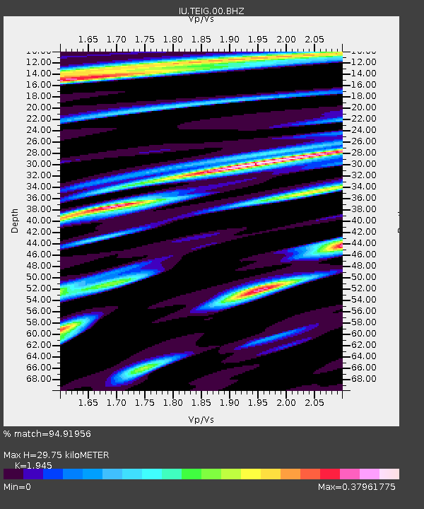
| Estimated Moho Depth: |
29.75 km |
| Estimated Crust Vp/Vs: |
1.95 |
| Assumed Crust Vp: |
5.817 km/s |
| Estimated Crust Vs: |
2.991 km/s |
| Estimated Crust Poisson's Ratio: |
0.32 |
|
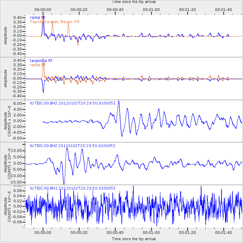
| Radial Match: |
94.91956 % |
| Radial Bump: |
280 |
| Transverse Match: |
94.82161 % |
| Transverse Bump: |
285 |
| SOD ConfigId: |
617450 |
| Insert Time: |
2013-10-01 16:40:39.086 +0000 |
| GWidth: |
2.5 |
| Max Bumps: |
400 |
| Tol: |
0.001 |
|
Signal To Noise
| Channel | StoN | STA | LTA |
| IU:TEIG:00:BHZ:20110102T20:29:50.910005Z | 14.213058 | 2.603582E-6 | 1.831824E-7 |
| IU:TEIG:00:BH1:20110102T20:29:50.910005Z | 0.8573062 | 2.2018616E-8 | 2.5683493E-8 |
| IU:TEIG:00:BH2:20110102T20:29:50.910005Z | 5.4601803 | 1.2158121E-6 | 2.2266885E-7 |
| Arrivals |
| Ps | 5.0 SECOND |
| PpPs | 15 SECOND |
| PsPs/PpSs | 20 SECOND |


