You are here: Home > Network List > II - Global Seismograph Network (GSN - IRIS/IDA) Stations List
> Station PALK Pallekele, Sri Lanka > Earthquake Result Viewer
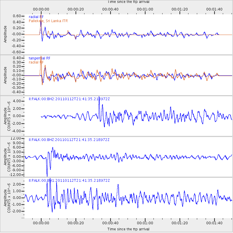
PALK Pallekele, Sri Lanka - Earthquake Result Viewer
*The percent match for this event was below the threshold and hence no stack was calculated.
| Earthquake location: |
Bonin Islands, Japan Region |
| Earthquake latitude/longitude: |
27.0/139.9 |
| Earthquake time(UTC): |
2011/01/12 (012) 21:32:55 GMT |
| Earthquake Depth: |
528 km |
| Earthquake Magnitude: |
6.2 MB, 6.5 MW, 6.5 MW |
| Earthquake Catalog/Contributor: |
WHDF/NEIC |
|
| Network: |
II Global Seismograph Network (GSN - IRIS/IDA) |
| Station: |
PALK Pallekele, Sri Lanka |
| Lat/Lon: |
7.27 N/80.70 E |
| Elevation: |
460 m |
|
| Distance: |
59.3 deg |
| Az: |
262.166 deg |
| Baz: |
63.018 deg |
| Ray Param: |
$rayparam |
*The percent match for this event was below the threshold and hence was not used in the summary stack. |
|
| Radial Match: |
76.0608 % |
| Radial Bump: |
400 |
| Transverse Match: |
57.053127 % |
| Transverse Bump: |
400 |
| SOD ConfigId: |
617450 |
| Insert Time: |
2013-10-01 17:10:52.504 +0000 |
| GWidth: |
2.5 |
| Max Bumps: |
400 |
| Tol: |
0.001 |
|
Signal To Noise
| Channel | StoN | STA | LTA |
| II:PALK:00:BHZ:20110112T21:41:35.218972Z | 7.607843 | 3.5840844E-6 | 4.7110393E-7 |
| II:PALK:00:BH1:20110112T21:41:35.218972Z | 2.042055 | 7.477594E-7 | 3.6617985E-7 |
| II:PALK:00:BH2:20110112T21:41:35.218972Z | 4.429612 | 1.4351865E-6 | 3.2399822E-7 |
| Arrivals |
| Ps | |
| PpPs | |
| PsPs/PpSs | |


