You are here: Home > Network List > IU - Global Seismograph Network (GSN - IRIS/USGS) Stations List
> Station JOHN Johnston Island, USA > Earthquake Result Viewer
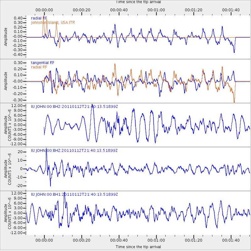
JOHN Johnston Island, USA - Earthquake Result Viewer
*The percent match for this event was below the threshold and hence no stack was calculated.
| Earthquake location: |
Bonin Islands, Japan Region |
| Earthquake latitude/longitude: |
27.0/139.9 |
| Earthquake time(UTC): |
2011/01/12 (012) 21:32:55 GMT |
| Earthquake Depth: |
528 km |
| Earthquake Magnitude: |
6.2 MB, 6.5 MW, 6.5 MW |
| Earthquake Catalog/Contributor: |
WHDF/NEIC |
|
| Network: |
IU Global Seismograph Network (GSN - IRIS/USGS) |
| Station: |
JOHN Johnston Island, USA |
| Lat/Lon: |
16.73 N/169.53 W |
| Elevation: |
2.0 m |
|
| Distance: |
47.8 deg |
| Az: |
91.475 deg |
| Baz: |
291.402 deg |
| Ray Param: |
$rayparam |
*The percent match for this event was below the threshold and hence was not used in the summary stack. |
|
| Radial Match: |
43.676006 % |
| Radial Bump: |
400 |
| Transverse Match: |
58.721817 % |
| Transverse Bump: |
400 |
| SOD ConfigId: |
617450 |
| Insert Time: |
2013-10-01 17:11:16.972 +0000 |
| GWidth: |
2.5 |
| Max Bumps: |
400 |
| Tol: |
0.001 |
|
Signal To Noise
| Channel | StoN | STA | LTA |
| IU:JOHN:00:BHZ:20110112T21:40:13.51899Z | 2.3089004 | 8.705927E-6 | 3.7705947E-6 |
| IU:JOHN:00:BH1:20110112T21:40:13.51899Z | 0.5788786 | 1.8677309E-6 | 3.226464E-6 |
| IU:JOHN:00:BH2:20110112T21:40:13.51899Z | 0.9066843 | 3.2313283E-6 | 3.5638957E-6 |
| Arrivals |
| Ps | |
| PpPs | |
| PsPs/PpSs | |


