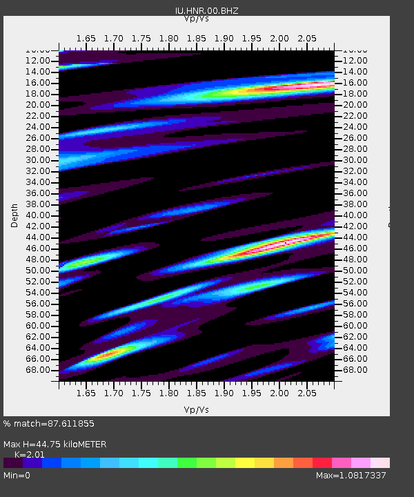
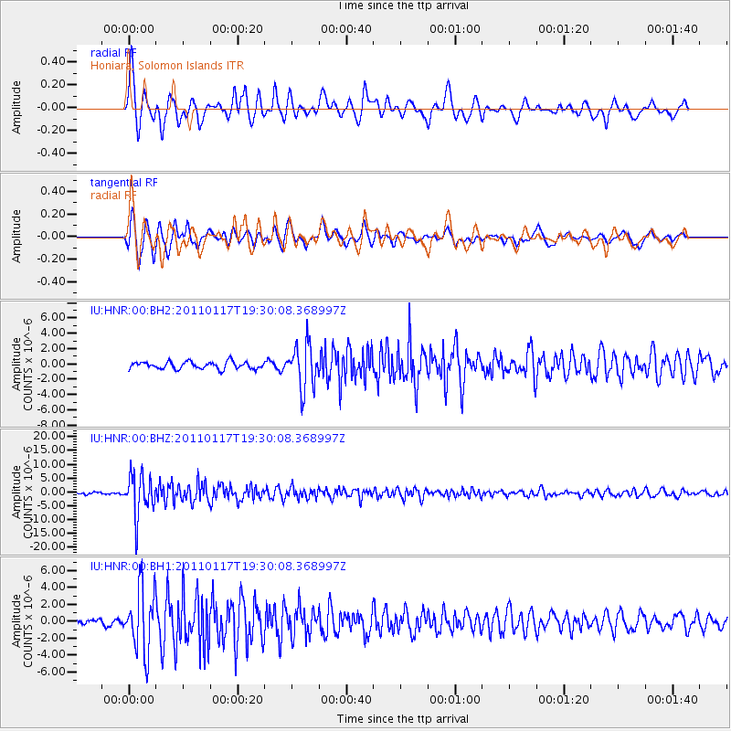
HNR Honiara, Solomon Islands - Earthquake Result Viewer

Earthquake location: Southern Sumatra, Indonesia
Earthquake latitude/longitude: -5.0/102.6
Earthquake time(UTC): 2011/01/17 (017) 19:20:57 GMT
Earthquake Depth: 36 km
Earthquake Magnitude: 6.1 MB, 5.9 MS, 6.0 MW, 6.0 MW
Earthquake Catalog/Contributor: WHDF/NEIC
Network: IU Global Seismograph Network (GSN - IRIS/USGS)
Station: HNR Honiara, Solomon Islands
Lat/Lon: 9.44 S/159.95 E
Elevation: 100 m
Distance: 57.0 deg
Az: 97.945 deg
Baz: 270.12 deg
Ray Param: 0.0637297
Estimated Moho Depth: 44.75 km
Estimated Crust Vp/Vs: 2.01
Assumed Crust Vp: 6.183 km/s
Estimated Crust Vs: 3.076 km/s
Estimated Crust Poisson's Ratio: 0.34
Radial Match: 87.611855 %
Radial Bump: 400
Transverse Match: 89.98224 %
Transverse Bump: 400
SOD ConfigId: 617450
Insert Time: 2013-10-01 17:23:55.348 +0000
GWidth: 2.5
Max Bumps: 400
Tol: 0.001

Signal To Noise

ChannelStoNSTALTA
IU:HNR:00:BHZ:20110117T19:30:08.368997Z20.2692877.496449E-63.6984275E-7
IU:HNR:00:BH1:20110117T19:30:08.368997Z10.3609423.8091425E-63.6764442E-7
IU:HNR:00:BH2:20110117T19:30:08.368997Z6.2120812.8732327E-64.6252336E-7
Arrivals
Ps7.6 SECOND
PpPs21 SECOND
PsPs/PpSs29 SECOND