You are here: Home > Network List > IU - Global Seismograph Network (GSN - IRIS/USGS) Stations List
> Station JOHN Johnston Island, USA > Earthquake Result Viewer
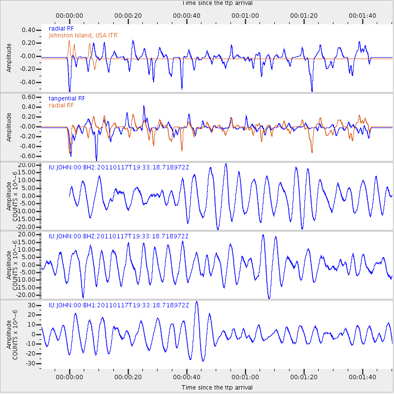
JOHN Johnston Island, USA - Earthquake Result Viewer
*The percent match for this event was below the threshold and hence no stack was calculated.
| Earthquake location: |
Southern Sumatra, Indonesia |
| Earthquake latitude/longitude: |
-5.0/102.6 |
| Earthquake time(UTC): |
2011/01/17 (017) 19:20:57 GMT |
| Earthquake Depth: |
36 km |
| Earthquake Magnitude: |
6.1 MB, 5.9 MS, 6.0 MW, 6.0 MW |
| Earthquake Catalog/Contributor: |
WHDF/NEIC |
|
| Network: |
IU Global Seismograph Network (GSN - IRIS/USGS) |
| Station: |
JOHN Johnston Island, USA |
| Lat/Lon: |
16.73 N/169.53 W |
| Elevation: |
2.0 m |
|
| Distance: |
89.4 deg |
| Az: |
73.247 deg |
| Baz: |
264.59 deg |
| Ray Param: |
$rayparam |
*The percent match for this event was below the threshold and hence was not used in the summary stack. |
|
| Radial Match: |
72.73186 % |
| Radial Bump: |
395 |
| Transverse Match: |
65.52235 % |
| Transverse Bump: |
400 |
| SOD ConfigId: |
617450 |
| Insert Time: |
2013-10-01 17:23:56.725 +0000 |
| GWidth: |
2.5 |
| Max Bumps: |
400 |
| Tol: |
0.001 |
|
Signal To Noise
| Channel | StoN | STA | LTA |
| IU:JOHN:00:BHZ:20110117T19:33:18.718972Z | 2.3901768 | 9.765154E-6 | 4.085536E-6 |
| IU:JOHN:00:BH1:20110117T19:33:18.718972Z | 1.8980113 | 1.4457294E-5 | 7.6170745E-6 |
| IU:JOHN:00:BH2:20110117T19:33:18.718972Z | 0.4659127 | 2.7231656E-6 | 5.8447977E-6 |
| Arrivals |
| Ps | |
| PpPs | |
| PsPs/PpSs | |


