You are here: Home > Network List > IU - Global Seismograph Network (GSN - IRIS/USGS) Stations List
> Station HNR Honiara, Solomon Islands > Earthquake Result Viewer
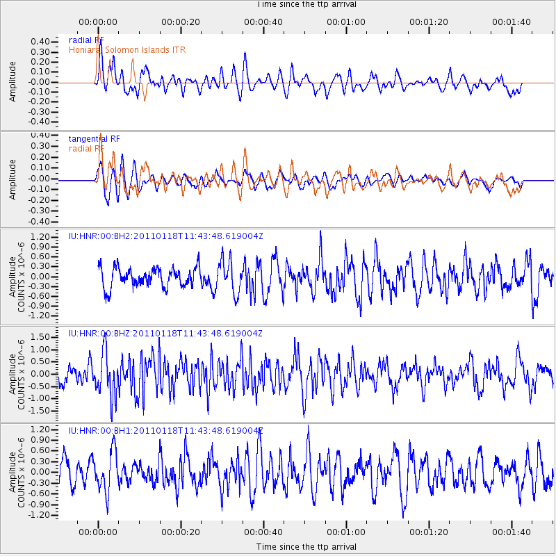
HNR Honiara, Solomon Islands - Earthquake Result Viewer
*The percent match for this event was below the threshold and hence no stack was calculated.
| Earthquake location: |
Northern Sumatra, Indonesia |
| Earthquake latitude/longitude: |
2.6/96.4 |
| Earthquake time(UTC): |
2011/01/18 (018) 11:33:44 GMT |
| Earthquake Depth: |
17 km |
| Earthquake Magnitude: |
5.7 MB, 5.9 MS, 5.9 MW, 5.9 MW |
| Earthquake Catalog/Contributor: |
WHDF/NEIC |
|
| Network: |
IU Global Seismograph Network (GSN - IRIS/USGS) |
| Station: |
HNR Honiara, Solomon Islands |
| Lat/Lon: |
9.44 S/159.95 E |
| Elevation: |
100 m |
|
| Distance: |
64.4 deg |
| Az: |
101.69 deg |
| Baz: |
277.481 deg |
| Ray Param: |
$rayparam |
*The percent match for this event was below the threshold and hence was not used in the summary stack. |
|
| Radial Match: |
55.977074 % |
| Radial Bump: |
400 |
| Transverse Match: |
64.60914 % |
| Transverse Bump: |
400 |
| SOD ConfigId: |
617450 |
| Insert Time: |
2013-10-01 17:25:56.284 +0000 |
| GWidth: |
2.5 |
| Max Bumps: |
400 |
| Tol: |
0.001 |
|
Signal To Noise
| Channel | StoN | STA | LTA |
| IU:HNR:00:BHZ:20110118T11:43:48.619004Z | 2.3298297 | 9.108343E-7 | 3.9094454E-7 |
| IU:HNR:00:BH1:20110118T11:43:48.619004Z | 1.7267444 | 5.726348E-7 | 3.3162684E-7 |
| IU:HNR:00:BH2:20110118T11:43:48.619004Z | 1.7384108 | 5.0961404E-7 | 2.9314938E-7 |
| Arrivals |
| Ps | |
| PpPs | |
| PsPs/PpSs | |


