You are here: Home > Network List > IU - Global Seismograph Network (GSN - IRIS/USGS) Stations List
> Station JOHN Johnston Island, USA > Earthquake Result Viewer
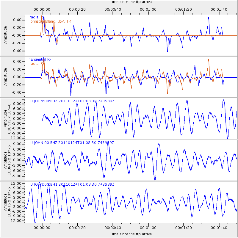
JOHN Johnston Island, USA - Earthquake Result Viewer
*The percent match for this event was below the threshold and hence no stack was calculated.
| Earthquake location: |
Tonga Islands |
| Earthquake latitude/longitude: |
-19.2/-173.5 |
| Earthquake time(UTC): |
2011/01/24 (024) 01:02:02 GMT |
| Earthquake Depth: |
16 km |
| Earthquake Magnitude: |
5.5 MB, 5.8 MS, 5.7 MW, 5.7 MW |
| Earthquake Catalog/Contributor: |
WHDF/NEIC |
|
| Network: |
IU Global Seismograph Network (GSN - IRIS/USGS) |
| Station: |
JOHN Johnston Island, USA |
| Lat/Lon: |
16.73 N/169.53 W |
| Elevation: |
2.0 m |
|
| Distance: |
35.9 deg |
| Az: |
6.51 deg |
| Baz: |
186.42 deg |
| Ray Param: |
$rayparam |
*The percent match for this event was below the threshold and hence was not used in the summary stack. |
|
| Radial Match: |
50.442432 % |
| Radial Bump: |
337 |
| Transverse Match: |
57.280296 % |
| Transverse Bump: |
332 |
| SOD ConfigId: |
617450 |
| Insert Time: |
2013-10-01 17:35:23.988 +0000 |
| GWidth: |
2.5 |
| Max Bumps: |
400 |
| Tol: |
0.001 |
|
Signal To Noise
| Channel | StoN | STA | LTA |
| IU:JOHN:00:BHZ:20110124T01:08:30.743989Z | 0.8654486 | 2.5792149E-6 | 2.9802056E-6 |
| IU:JOHN:00:BH1:20110124T01:08:30.743989Z | 2.0001168 | 8.115883E-6 | 4.0577047E-6 |
| IU:JOHN:00:BH2:20110124T01:08:30.743989Z | 1.7838309 | 7.113399E-6 | 3.987709E-6 |
| Arrivals |
| Ps | |
| PpPs | |
| PsPs/PpSs | |


