You are here: Home > Network List > IU - Global Seismograph Network (GSN - IRIS/USGS) Stations List
> Station RSSD Black Hills, South Dakota, USA > Earthquake Result Viewer
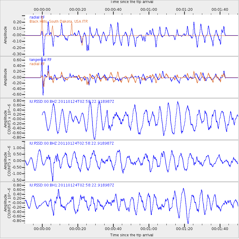
RSSD Black Hills, South Dakota, USA - Earthquake Result Viewer
*The percent match for this event was below the threshold and hence no stack was calculated.
| Earthquake location: |
Tajikistan |
| Earthquake latitude/longitude: |
38.4/72.8 |
| Earthquake time(UTC): |
2011/01/24 (024) 02:45:31 GMT |
| Earthquake Depth: |
110 km |
| Earthquake Magnitude: |
6.0 MB, 6.1 MW, 6.0 MW |
| Earthquake Catalog/Contributor: |
WHDF/NEIC |
|
| Network: |
IU Global Seismograph Network (GSN - IRIS/USGS) |
| Station: |
RSSD Black Hills, South Dakota, USA |
| Lat/Lon: |
44.12 N/104.04 W |
| Elevation: |
2090 m |
|
| Distance: |
97.8 deg |
| Az: |
357.694 deg |
| Baz: |
2.515 deg |
| Ray Param: |
$rayparam |
*The percent match for this event was below the threshold and hence was not used in the summary stack. |
|
| Radial Match: |
59.66678 % |
| Radial Bump: |
400 |
| Transverse Match: |
70.05392 % |
| Transverse Bump: |
400 |
| SOD ConfigId: |
617450 |
| Insert Time: |
2013-10-01 17:38:20.980 +0000 |
| GWidth: |
2.5 |
| Max Bumps: |
400 |
| Tol: |
0.001 |
|
Signal To Noise
| Channel | StoN | STA | LTA |
| IU:RSSD:00:BHZ:20110124T02:58:22.918987Z | 1.4810045 | 2.967707E-7 | 2.0038476E-7 |
| IU:RSSD:00:BH1:20110124T02:58:22.918987Z | 0.43824282 | 8.5831694E-8 | 1.9585418E-7 |
| IU:RSSD:00:BH2:20110124T02:58:22.918987Z | 1.770135 | 5.5541744E-7 | 3.1377124E-7 |
| Arrivals |
| Ps | |
| PpPs | |
| PsPs/PpSs | |


