You are here: Home > Network List > II - Global Seismograph Network (GSN - IRIS/IDA) Stations List
> Station WRAB Tennant Creek, NT, Australia > Earthquake Result Viewer
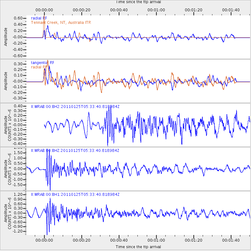
WRAB Tennant Creek, NT, Australia - Earthquake Result Viewer
*The percent match for this event was below the threshold and hence no stack was calculated.
| Earthquake location: |
Near East Coast Of Honshu, Japan |
| Earthquake latitude/longitude: |
35.1/141.1 |
| Earthquake time(UTC): |
2011/01/25 (025) 05:24:40 GMT |
| Earthquake Depth: |
14 km |
| Earthquake Magnitude: |
5.6 MB |
| Earthquake Catalog/Contributor: |
NEIC PDE/NEIC PDE-M |
|
| Network: |
II Global Seismograph Network (GSN - IRIS/IDA) |
| Station: |
WRAB Tennant Creek, NT, Australia |
| Lat/Lon: |
19.93 S/134.36 E |
| Elevation: |
366 m |
|
| Distance: |
55.1 deg |
| Az: |
187.754 deg |
| Baz: |
6.751 deg |
| Ray Param: |
$rayparam |
*The percent match for this event was below the threshold and hence was not used in the summary stack. |
|
| Radial Match: |
70.585945 % |
| Radial Bump: |
400 |
| Transverse Match: |
52.101177 % |
| Transverse Bump: |
400 |
| SOD ConfigId: |
617450 |
| Insert Time: |
2013-10-01 17:39:57.471 +0000 |
| GWidth: |
2.5 |
| Max Bumps: |
400 |
| Tol: |
0.001 |
|
Signal To Noise
| Channel | StoN | STA | LTA |
| II:WRAB:00:BHZ:20110125T05:33:40.818984Z | 5.6584325 | 8.3122865E-7 | 1.4690087E-7 |
| II:WRAB:00:BH1:20110125T05:33:40.818984Z | 3.8382814 | 4.9919294E-7 | 1.3005636E-7 |
| II:WRAB:00:BH2:20110125T05:33:40.818984Z | 1.7631649 | 1.6875481E-7 | 9.57113E-8 |
| Arrivals |
| Ps | |
| PpPs | |
| PsPs/PpSs | |


