You are here: Home > Network List > II - Global Seismograph Network (GSN - IRIS/IDA) Stations List
> Station WRAB Tennant Creek, NT, Australia > Earthquake Result Viewer
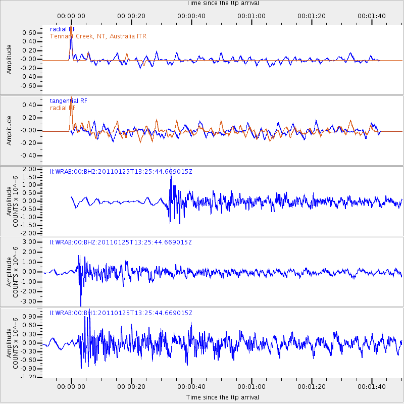
WRAB Tennant Creek, NT, Australia - Earthquake Result Viewer
*The percent match for this event was below the threshold and hence no stack was calculated.
| Earthquake location: |
Kermadec Islands, New Zealand |
| Earthquake latitude/longitude: |
-30.1/-177.9 |
| Earthquake time(UTC): |
2011/01/25 (025) 13:18:10 GMT |
| Earthquake Depth: |
35 km |
| Earthquake Magnitude: |
5.8 MB |
| Earthquake Catalog/Contributor: |
NEIC PDE/NEIC PDE-M |
|
| Network: |
II Global Seismograph Network (GSN - IRIS/IDA) |
| Station: |
WRAB Tennant Creek, NT, Australia |
| Lat/Lon: |
19.93 S/134.36 E |
| Elevation: |
366 m |
|
| Distance: |
44.1 deg |
| Az: |
271.8 deg |
| Baz: |
112.928 deg |
| Ray Param: |
$rayparam |
*The percent match for this event was below the threshold and hence was not used in the summary stack. |
|
| Radial Match: |
56.07499 % |
| Radial Bump: |
400 |
| Transverse Match: |
54.127472 % |
| Transverse Bump: |
400 |
| SOD ConfigId: |
617450 |
| Insert Time: |
2013-10-01 17:41:38.754 +0000 |
| GWidth: |
2.5 |
| Max Bumps: |
400 |
| Tol: |
0.001 |
|
Signal To Noise
| Channel | StoN | STA | LTA |
| II:WRAB:00:BHZ:20110125T13:25:44.669015Z | 7.2368608 | 9.074249E-7 | 1.253893E-7 |
| II:WRAB:00:BH1:20110125T13:25:44.669015Z | 1.8678463 | 2.747954E-7 | 1.4711887E-7 |
| II:WRAB:00:BH2:20110125T13:25:44.669015Z | 4.7784934 | 5.7496953E-7 | 1.2032444E-7 |
| Arrivals |
| Ps | |
| PpPs | |
| PsPs/PpSs | |


