You are here: Home > Network List > II - Global Seismograph Network (GSN - IRIS/IDA) Stations List
> Station KAPI Kappang, Sulawesi, Indonesia > Earthquake Result Viewer
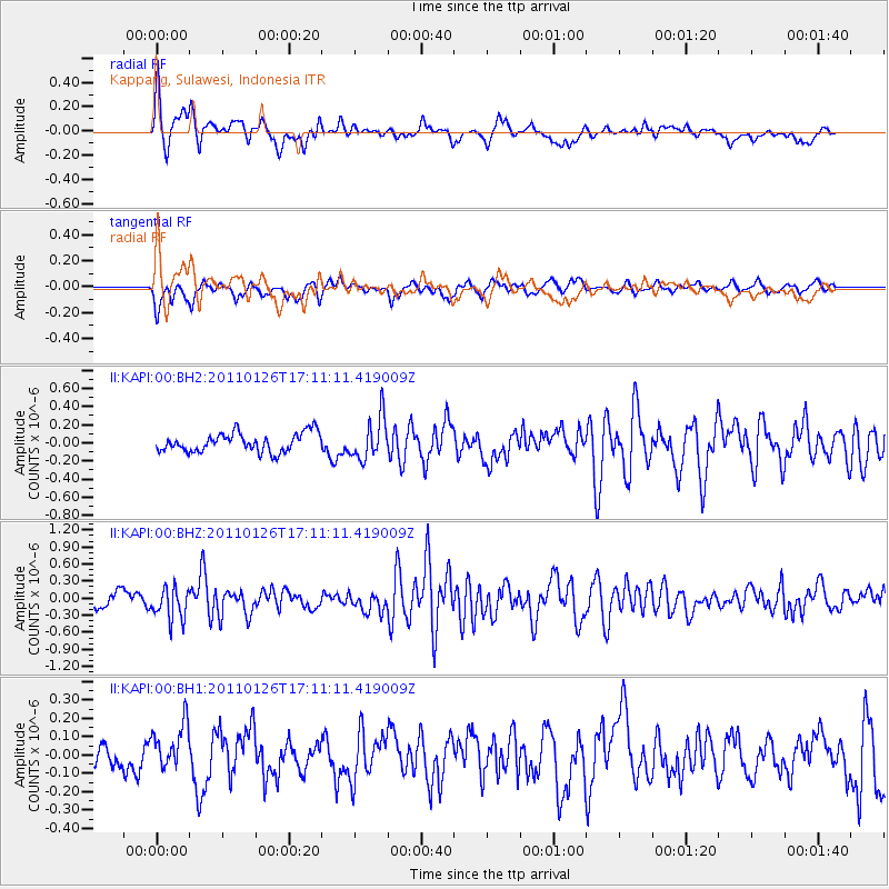
KAPI Kappang, Sulawesi, Indonesia - Earthquake Result Viewer
*The percent match for this event was below the threshold and hence no stack was calculated.
| Earthquake location: |
Santa Cruz Islands |
| Earthquake latitude/longitude: |
-11.0/166.3 |
| Earthquake time(UTC): |
2011/01/26 (026) 17:03:30 GMT |
| Earthquake Depth: |
148 km |
| Earthquake Magnitude: |
5.8 MB, 5.7 MW |
| Earthquake Catalog/Contributor: |
WHDF/NEIC |
|
| Network: |
II Global Seismograph Network (GSN - IRIS/IDA) |
| Station: |
KAPI Kappang, Sulawesi, Indonesia |
| Lat/Lon: |
5.01 S/119.75 E |
| Elevation: |
300 m |
|
| Distance: |
46.4 deg |
| Az: |
273.544 deg |
| Baz: |
100.372 deg |
| Ray Param: |
$rayparam |
*The percent match for this event was below the threshold and hence was not used in the summary stack. |
|
| Radial Match: |
73.45438 % |
| Radial Bump: |
400 |
| Transverse Match: |
61.842373 % |
| Transverse Bump: |
381 |
| SOD ConfigId: |
617450 |
| Insert Time: |
2013-10-01 17:44:17.304 +0000 |
| GWidth: |
2.5 |
| Max Bumps: |
400 |
| Tol: |
0.001 |
|
Signal To Noise
| Channel | StoN | STA | LTA |
| II:KAPI:00:BHZ:20110126T17:11:11.419009Z | 2.720648 | 2.8005212E-7 | 1.02935815E-7 |
| II:KAPI:00:BH1:20110126T17:11:11.419009Z | 2.0172038 | 1.2591353E-7 | 6.2419836E-8 |
| II:KAPI:00:BH2:20110126T17:11:11.419009Z | 2.2483852 | 2.3147018E-7 | 1.0294953E-7 |
| Arrivals |
| Ps | |
| PpPs | |
| PsPs/PpSs | |


