You are here: Home > Network List > II - Global Seismograph Network (GSN - IRIS/IDA) Stations List
> Station WRAB Tennant Creek, NT, Australia > Earthquake Result Viewer
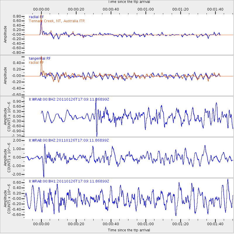
WRAB Tennant Creek, NT, Australia - Earthquake Result Viewer
*The percent match for this event was below the threshold and hence no stack was calculated.
| Earthquake location: |
Santa Cruz Islands |
| Earthquake latitude/longitude: |
-11.0/166.3 |
| Earthquake time(UTC): |
2011/01/26 (026) 17:03:30 GMT |
| Earthquake Depth: |
148 km |
| Earthquake Magnitude: |
5.8 MB, 5.7 MW |
| Earthquake Catalog/Contributor: |
WHDF/NEIC |
|
| Network: |
II Global Seismograph Network (GSN - IRIS/IDA) |
| Station: |
WRAB Tennant Creek, NT, Australia |
| Lat/Lon: |
19.93 S/134.36 E |
| Elevation: |
366 m |
|
| Distance: |
32.0 deg |
| Az: |
249.995 deg |
| Baz: |
78.7 deg |
| Ray Param: |
$rayparam |
*The percent match for this event was below the threshold and hence was not used in the summary stack. |
|
| Radial Match: |
66.583374 % |
| Radial Bump: |
371 |
| Transverse Match: |
37.92118 % |
| Transverse Bump: |
400 |
| SOD ConfigId: |
617450 |
| Insert Time: |
2013-10-01 17:44:22.438 +0000 |
| GWidth: |
2.5 |
| Max Bumps: |
400 |
| Tol: |
0.001 |
|
Signal To Noise
| Channel | StoN | STA | LTA |
| II:WRAB:00:BHZ:20110126T17:09:11.86899Z | 4.9004354 | 7.575546E-7 | 1.5458924E-7 |
| II:WRAB:00:BH1:20110126T17:09:11.86899Z | 1.2148063 | 2.3458584E-7 | 1.9310555E-7 |
| II:WRAB:00:BH2:20110126T17:09:11.86899Z | 2.3765566 | 4.5567228E-7 | 1.9173635E-7 |
| Arrivals |
| Ps | |
| PpPs | |
| PsPs/PpSs | |


