You are here: Home > Network List > AV - Alaska Volcano Observatory Stations List
> Station MAPS Pakushin Southeast, Makushin Volcano, Alaska > Earthquake Result Viewer
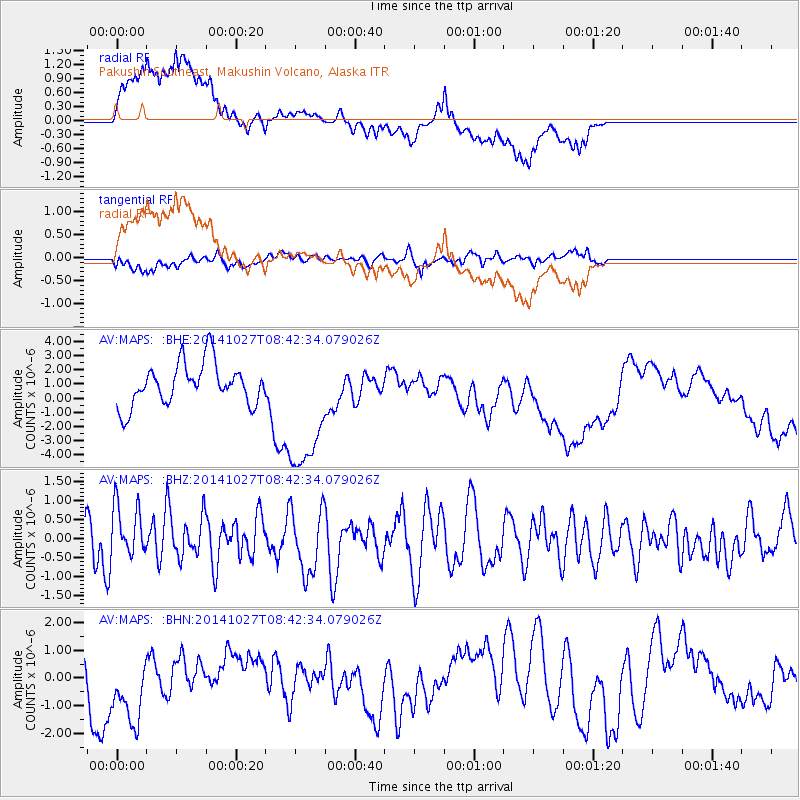
MAPS Pakushin Southeast, Makushin Volcano, Alaska - Earthquake Result Viewer
*The percent match for this event was below the threshold and hence no stack was calculated.
| Earthquake location: |
Mindanao, Philippines |
| Earthquake latitude/longitude: |
9.7/126.7 |
| Earthquake time(UTC): |
2014/10/27 (300) 08:32:08 GMT |
| Earthquake Depth: |
46 km |
| Earthquake Magnitude: |
5.4 MW |
| Earthquake Catalog/Contributor: |
ISC/ISC |
|
| Network: |
AV Alaska Volcano Observatory |
| Station: |
MAPS Pakushin Southeast, Makushin Volcano, Alaska |
| Lat/Lon: |
53.81 N/166.94 W |
| Elevation: |
333 m |
|
| Distance: |
68.3 deg |
| Az: |
35.773 deg |
| Baz: |
256.339 deg |
| Ray Param: |
$rayparam |
*The percent match for this event was below the threshold and hence was not used in the summary stack. |
|
| Radial Match: |
47.169357 % |
| Radial Bump: |
400 |
| Transverse Match: |
54.95075 % |
| Transverse Bump: |
400 |
| SOD ConfigId: |
3390531 |
| Insert Time: |
2019-04-14 18:37:08.840 +0000 |
| GWidth: |
2.5 |
| Max Bumps: |
400 |
| Tol: |
0.001 |
|
Signal To Noise
| Channel | StoN | STA | LTA |
| AV:MAPS: :BHZ:20141027T08:42:34.079026Z | 0.89170855 | 6.9778525E-7 | 7.825261E-7 |
| AV:MAPS: :BHN:20141027T08:42:34.079026Z | 1.9430455 | 1.5009566E-6 | 7.724763E-7 |
| AV:MAPS: :BHE:20141027T08:42:34.079026Z | 3.2698138 | 4.838276E-6 | 1.4796793E-6 |
| Arrivals |
| Ps | |
| PpPs | |
| PsPs/PpSs | |


