You are here: Home > Network List > IU - Global Seismograph Network (GSN - IRIS/USGS) Stations List
> Station HNR Honiara, Solomon Islands > Earthquake Result Viewer
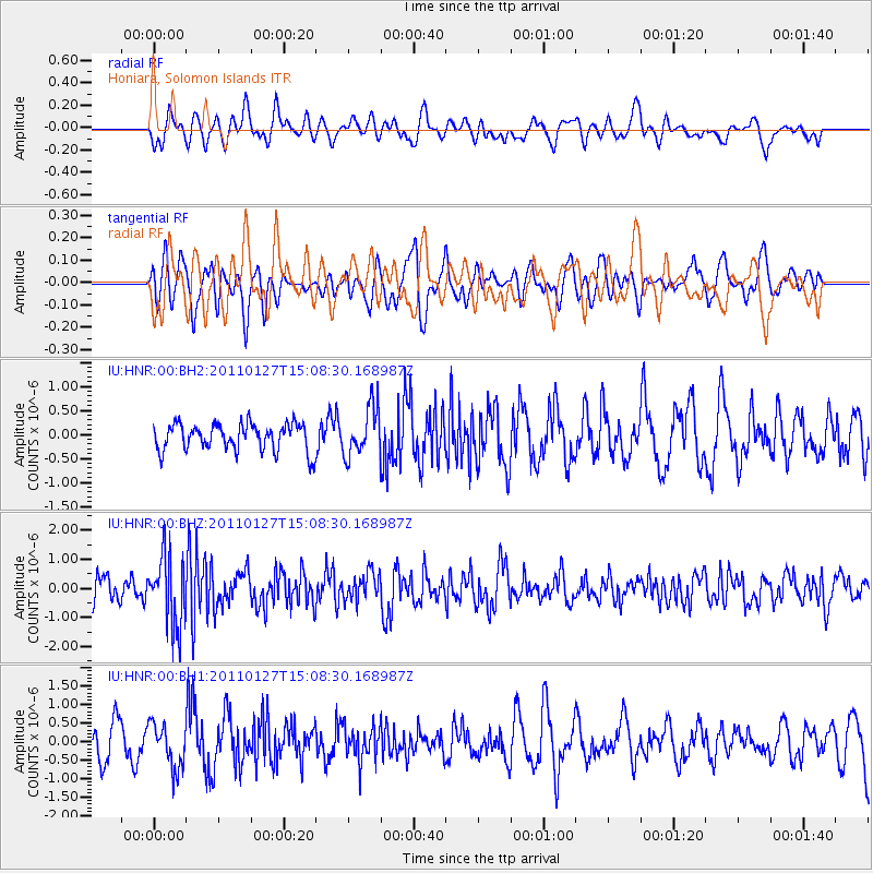
HNR Honiara, Solomon Islands - Earthquake Result Viewer
*The percent match for this event was below the threshold and hence no stack was calculated.
| Earthquake location: |
North Island, New Zealand |
| Earthquake latitude/longitude: |
-38.5/176.0 |
| Earthquake time(UTC): |
2011/01/27 (027) 15:02:46 GMT |
| Earthquake Depth: |
158 km |
| Earthquake Magnitude: |
5.6 MW, 5.6 MW |
| Earthquake Catalog/Contributor: |
NEIC PDE/NEIC PDE-M |
|
| Network: |
IU Global Seismograph Network (GSN - IRIS/USGS) |
| Station: |
HNR Honiara, Solomon Islands |
| Lat/Lon: |
9.44 S/159.95 E |
| Elevation: |
100 m |
|
| Distance: |
32.3 deg |
| Az: |
329.335 deg |
| Baz: |
156.072 deg |
| Ray Param: |
$rayparam |
*The percent match for this event was below the threshold and hence was not used in the summary stack. |
|
| Radial Match: |
52.289413 % |
| Radial Bump: |
400 |
| Transverse Match: |
56.00444 % |
| Transverse Bump: |
400 |
| SOD ConfigId: |
617450 |
| Insert Time: |
2013-10-01 17:51:18.424 +0000 |
| GWidth: |
2.5 |
| Max Bumps: |
400 |
| Tol: |
0.001 |
|
Signal To Noise
| Channel | StoN | STA | LTA |
| IU:HNR:00:BHZ:20110127T15:08:30.168987Z | 2.7626684 | 1.2444118E-6 | 4.5043836E-7 |
| IU:HNR:00:BH1:20110127T15:08:30.168987Z | 1.2694352 | 6.0606146E-7 | 4.774261E-7 |
| IU:HNR:00:BH2:20110127T15:08:30.168987Z | 1.8082342 | 5.082384E-7 | 2.810689E-7 |
| Arrivals |
| Ps | |
| PpPs | |
| PsPs/PpSs | |


