You are here: Home > Network List > II - Global Seismograph Network (GSN - IRIS/IDA) Stations List
> Station WRAB Tennant Creek, NT, Australia > Earthquake Result Viewer
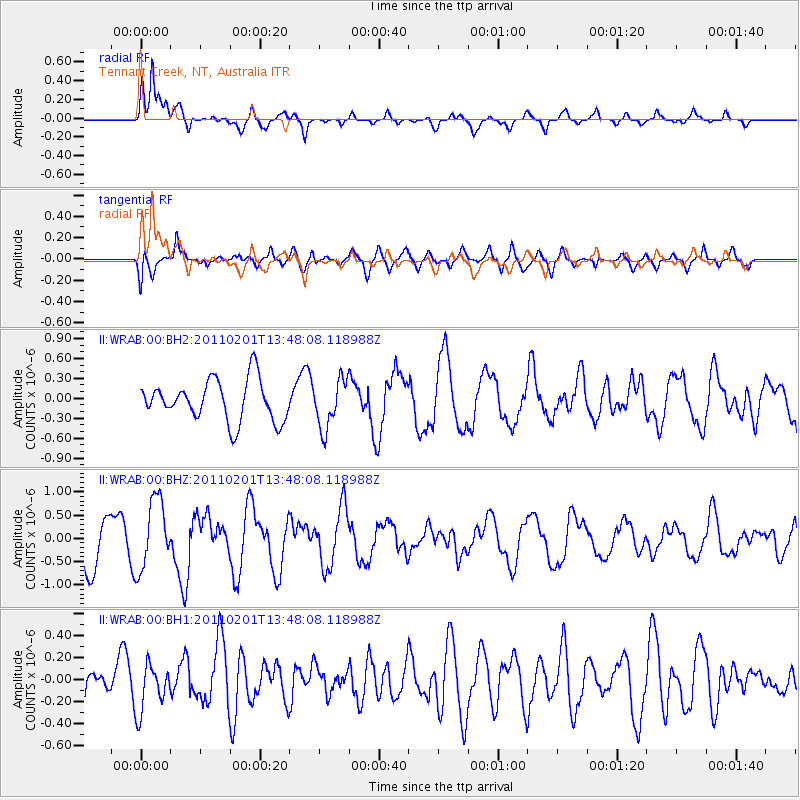
WRAB Tennant Creek, NT, Australia - Earthquake Result Viewer
*The percent match for this event was below the threshold and hence no stack was calculated.
| Earthquake location: |
Andaman Islands, India Region |
| Earthquake latitude/longitude: |
10.6/94.1 |
| Earthquake time(UTC): |
2011/02/01 (032) 13:39:47 GMT |
| Earthquake Depth: |
22 km |
| Earthquake Magnitude: |
5.5 MW, 5.5 MB, 5.6 MW |
| Earthquake Catalog/Contributor: |
NEIC PDE/NEIC PDE-M |
|
| Network: |
II Global Seismograph Network (GSN - IRIS/IDA) |
| Station: |
WRAB Tennant Creek, NT, Australia |
| Lat/Lon: |
19.93 S/134.36 E |
| Elevation: |
366 m |
|
| Distance: |
49.9 deg |
| Az: |
127.395 deg |
| Baz: |
303.884 deg |
| Ray Param: |
$rayparam |
*The percent match for this event was below the threshold and hence was not used in the summary stack. |
|
| Radial Match: |
78.90686 % |
| Radial Bump: |
400 |
| Transverse Match: |
72.221344 % |
| Transverse Bump: |
400 |
| SOD ConfigId: |
617450 |
| Insert Time: |
2013-10-01 17:59:40.952 +0000 |
| GWidth: |
2.5 |
| Max Bumps: |
400 |
| Tol: |
0.001 |
|
Signal To Noise
| Channel | StoN | STA | LTA |
| II:WRAB:00:BHZ:20110201T13:48:08.118988Z | 1.9400027 | 7.42271E-7 | 3.826134E-7 |
| II:WRAB:00:BH1:20110201T13:48:08.118988Z | 0.9543659 | 2.1382934E-7 | 2.2405384E-7 |
| II:WRAB:00:BH2:20110201T13:48:08.118988Z | 1.1881688 | 3.6343422E-7 | 3.058776E-7 |
| Arrivals |
| Ps | |
| PpPs | |
| PsPs/PpSs | |


