You are here: Home > Network List > II - Global Seismograph Network (GSN - IRIS/IDA) Stations List
> Station CMLA Cha de Macela, Sao Miguel Island, Azores > Earthquake Result Viewer
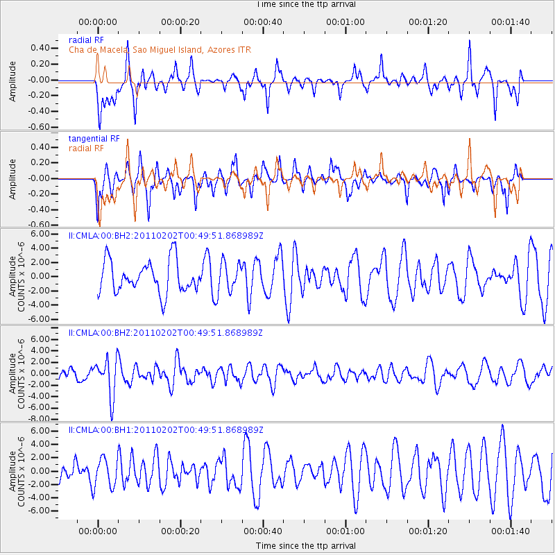
CMLA Cha de Macela, Sao Miguel Island, Azores - Earthquake Result Viewer
*The percent match for this event was below the threshold and hence no stack was calculated.
| Earthquake location: |
Alaska Peninsula |
| Earthquake latitude/longitude: |
55.0/-160.5 |
| Earthquake time(UTC): |
2011/02/02 (033) 00:38:17 GMT |
| Earthquake Depth: |
35 km |
| Earthquake Magnitude: |
5.9 MW, 5.6 MS, 5.8 MW, 5.9 MB |
| Earthquake Catalog/Contributor: |
NEIC PDE/NEIC PDE-M |
|
| Network: |
II Global Seismograph Network (GSN - IRIS/IDA) |
| Station: |
CMLA Cha de Macela, Sao Miguel Island, Azores |
| Lat/Lon: |
37.76 N/25.52 W |
| Elevation: |
429 m |
|
| Distance: |
79.9 deg |
| Az: |
34.738 deg |
| Baz: |
335.51 deg |
| Ray Param: |
$rayparam |
*The percent match for this event was below the threshold and hence was not used in the summary stack. |
|
| Radial Match: |
64.79644 % |
| Radial Bump: |
400 |
| Transverse Match: |
65.81399 % |
| Transverse Bump: |
354 |
| SOD ConfigId: |
617450 |
| Insert Time: |
2013-10-01 18:01:12.425 +0000 |
| GWidth: |
2.5 |
| Max Bumps: |
400 |
| Tol: |
0.001 |
|
Signal To Noise
| Channel | StoN | STA | LTA |
| II:CMLA:00:BHZ:20110202T00:49:51.868989Z | 1.7701752 | 3.3700073E-6 | 1.9037703E-6 |
| II:CMLA:00:BH1:20110202T00:49:51.868989Z | 0.63952464 | 2.1036783E-6 | 3.2894407E-6 |
| II:CMLA:00:BH2:20110202T00:49:51.868989Z | 0.87331456 | 1.9426473E-6 | 2.224453E-6 |
| Arrivals |
| Ps | |
| PpPs | |
| PsPs/PpSs | |


