You are here: Home > Network List > IU - Global Seismograph Network (GSN - IRIS/USGS) Stations List
> Station OTAV Otavalo, Ecuador > Earthquake Result Viewer
OTAV Otavalo, Ecuador - Earthquake Result Viewer
| Earthquake location: |
Alaska Peninsula |
| Earthquake latitude/longitude: |
55.0/-160.5 |
| Earthquake time(UTC): |
2011/02/02 (033) 00:38:17 GMT |
| Earthquake Depth: |
35 km |
| Earthquake Magnitude: |
5.9 MW, 5.6 MS, 5.8 MW, 5.9 MB |
| Earthquake Catalog/Contributor: |
NEIC PDE/NEIC PDE-M |
|
| Network: |
IU Global Seismograph Network (GSN - IRIS/USGS) |
| Station: |
OTAV Otavalo, Ecuador |
| Lat/Lon: |
0.24 N/78.45 W |
| Elevation: |
3510 m |
|
| Distance: |
85.2 deg |
| Az: |
96.403 deg |
| Baz: |
325.044 deg |
| Ray Param: |
0.044879016 |
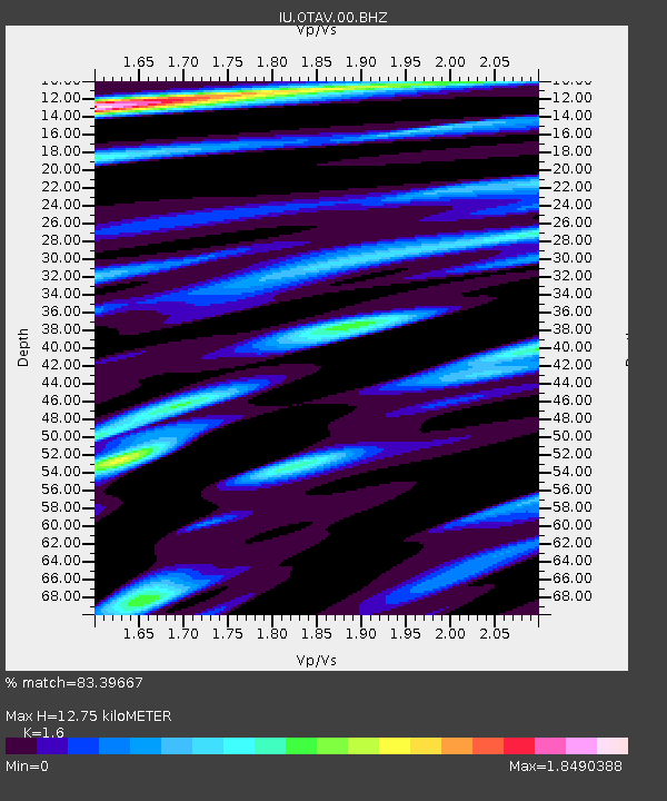
| Estimated Moho Depth: |
12.75 km |
| Estimated Crust Vp/Vs: |
1.60 |
| Assumed Crust Vp: |
6.472 km/s |
| Estimated Crust Vs: |
4.045 km/s |
| Estimated Crust Poisson's Ratio: |
0.18 |
|
| Radial Match: |
83.39667 % |
| Radial Bump: |
400 |
| Transverse Match: |
76.178406 % |
| Transverse Bump: |
400 |
| SOD ConfigId: |
617450 |
| Insert Time: |
2013-10-01 18:01:40.008 +0000 |
| GWidth: |
2.5 |
| Max Bumps: |
400 |
| Tol: |
0.001 |
|
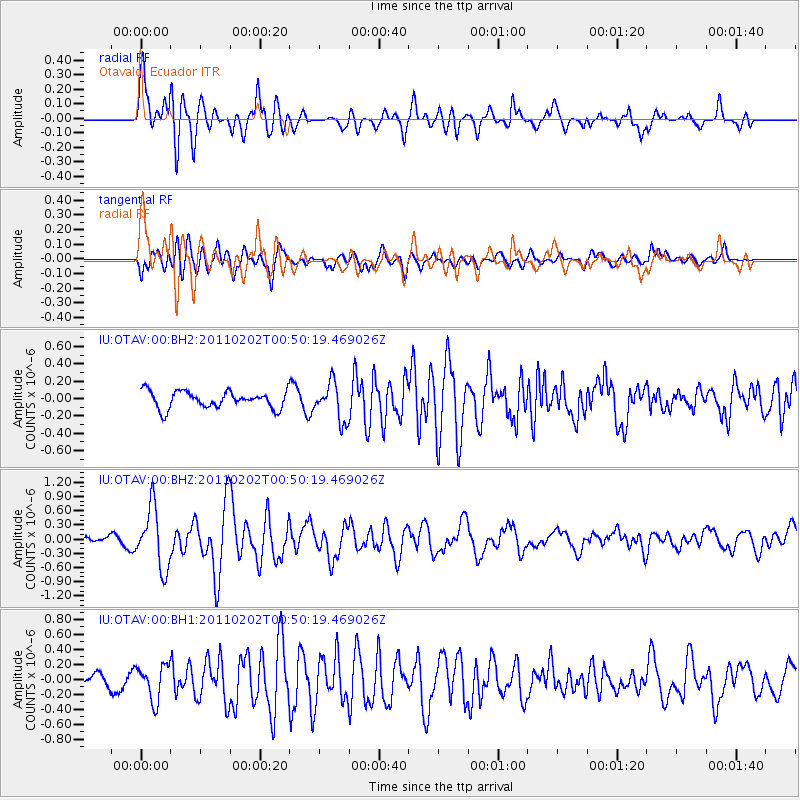
Signal To Noise
| Channel | StoN | STA | LTA |
| IU:OTAV:00:BHZ:20110202T00:50:19.469026Z | 6.473542 | 6.395025E-7 | 9.87871E-8 |
| IU:OTAV:00:BH1:20110202T00:50:19.469026Z | 2.2607272 | 2.3386292E-7 | 1.0344588E-7 |
| IU:OTAV:00:BH2:20110202T00:50:19.469026Z | 2.2058222 | 2.1748276E-7 | 9.8594874E-8 |
| Arrivals |
| Ps | 1.2 SECOND |
| PpPs | 5.0 SECOND |
| PsPs/PpSs | 6.2 SECOND |


