You are here: Home > Network List > II - Global Seismograph Network (GSN - IRIS/IDA) Stations List
> Station KAPI Kappang, Sulawesi, Indonesia > Earthquake Result Viewer
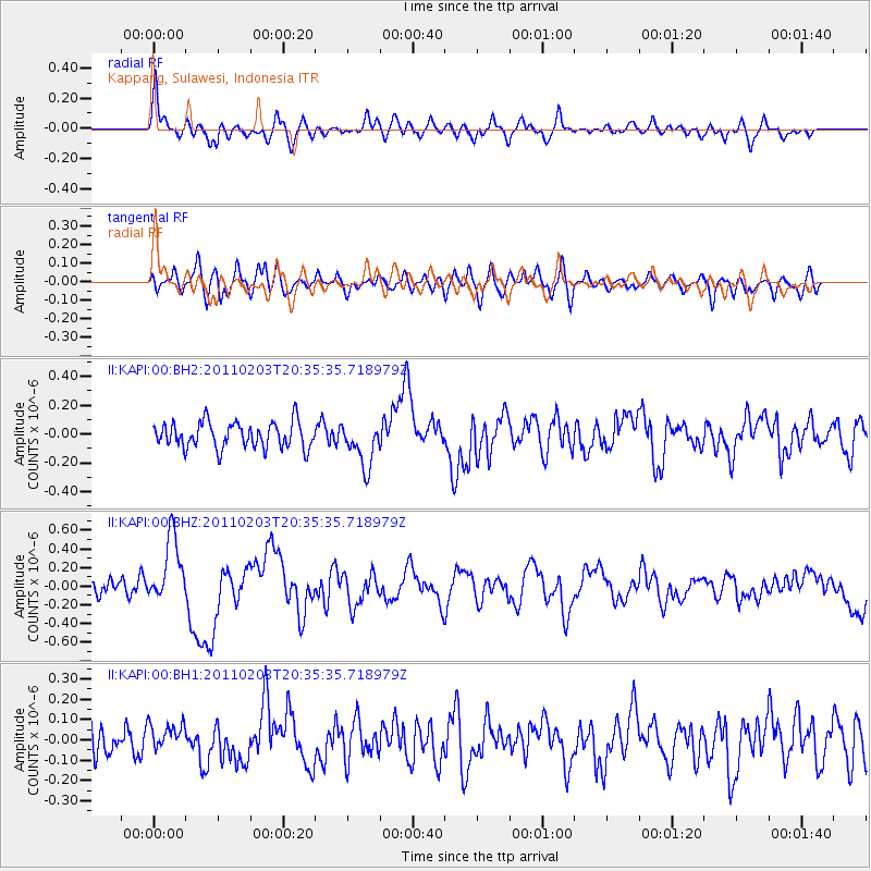
KAPI Kappang, Sulawesi, Indonesia - Earthquake Result Viewer
*The percent match for this event was below the threshold and hence no stack was calculated.
| Earthquake location: |
Tonga Islands |
| Earthquake latitude/longitude: |
-15.5/-173.1 |
| Earthquake time(UTC): |
2011/02/03 (034) 20:25:15 GMT |
| Earthquake Depth: |
10 km |
| Earthquake Magnitude: |
6.0 MW, 5.7 MS, 5.9 MW |
| Earthquake Catalog/Contributor: |
NEIC PDE/NEIC PDE-M |
|
| Network: |
II Global Seismograph Network (GSN - IRIS/IDA) |
| Station: |
KAPI Kappang, Sulawesi, Indonesia |
| Lat/Lon: |
5.01 S/119.75 E |
| Elevation: |
300 m |
|
| Distance: |
66.7 deg |
| Az: |
271.184 deg |
| Baz: |
104.65 deg |
| Ray Param: |
$rayparam |
*The percent match for this event was below the threshold and hence was not used in the summary stack. |
|
| Radial Match: |
69.48952 % |
| Radial Bump: |
400 |
| Transverse Match: |
63.48197 % |
| Transverse Bump: |
400 |
| SOD ConfigId: |
617450 |
| Insert Time: |
2013-10-01 18:04:03.479 +0000 |
| GWidth: |
2.5 |
| Max Bumps: |
400 |
| Tol: |
0.001 |
|
Signal To Noise
| Channel | StoN | STA | LTA |
| II:KAPI:00:BHZ:20110203T20:35:35.718979Z | 4.515964 | 3.5294747E-7 | 7.8155516E-8 |
| II:KAPI:00:BH1:20110203T20:35:35.718979Z | 0.9799918 | 6.747476E-8 | 6.885237E-8 |
| II:KAPI:00:BH2:20110203T20:35:35.718979Z | 1.7282418 | 1.5433912E-7 | 8.930412E-8 |
| Arrivals |
| Ps | |
| PpPs | |
| PsPs/PpSs | |


