You are here: Home > Network List > II - Global Seismograph Network (GSN - IRIS/IDA) Stations List
> Station WRAB Tennant Creek, NT, Australia > Earthquake Result Viewer
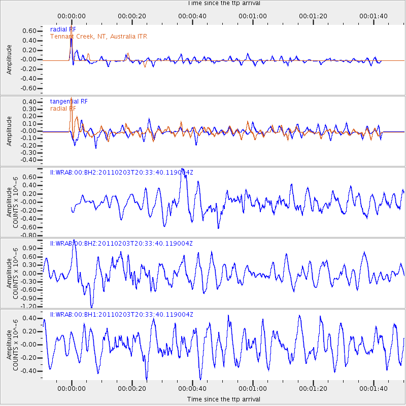
WRAB Tennant Creek, NT, Australia - Earthquake Result Viewer
*The percent match for this event was below the threshold and hence no stack was calculated.
| Earthquake location: |
Tonga Islands |
| Earthquake latitude/longitude: |
-15.5/-173.1 |
| Earthquake time(UTC): |
2011/02/03 (034) 20:25:15 GMT |
| Earthquake Depth: |
10 km |
| Earthquake Magnitude: |
6.0 MW, 5.7 MS, 5.9 MW |
| Earthquake Catalog/Contributor: |
NEIC PDE/NEIC PDE-M |
|
| Network: |
II Global Seismograph Network (GSN - IRIS/IDA) |
| Station: |
WRAB Tennant Creek, NT, Australia |
| Lat/Lon: |
19.93 S/134.36 E |
| Elevation: |
366 m |
|
| Distance: |
50.1 deg |
| Az: |
256.834 deg |
| Baz: |
93.846 deg |
| Ray Param: |
$rayparam |
*The percent match for this event was below the threshold and hence was not used in the summary stack. |
|
| Radial Match: |
61.436203 % |
| Radial Bump: |
371 |
| Transverse Match: |
56.92089 % |
| Transverse Bump: |
400 |
| SOD ConfigId: |
617450 |
| Insert Time: |
2013-10-01 18:04:07.204 +0000 |
| GWidth: |
2.5 |
| Max Bumps: |
400 |
| Tol: |
0.001 |
|
Signal To Noise
| Channel | StoN | STA | LTA |
| II:WRAB:00:BHZ:20110203T20:33:40.119004Z | 2.8884687 | 6.133772E-7 | 2.1235377E-7 |
| II:WRAB:00:BH1:20110203T20:33:40.119004Z | 0.81866306 | 1.7188219E-7 | 2.0995475E-7 |
| II:WRAB:00:BH2:20110203T20:33:40.119004Z | 2.0032456 | 2.810419E-7 | 1.4029328E-7 |
| Arrivals |
| Ps | |
| PpPs | |
| PsPs/PpSs | |


