You are here: Home > Network List > IU - Global Seismograph Network (GSN - IRIS/USGS) Stations List
> Station HNR Honiara, Solomon Islands > Earthquake Result Viewer
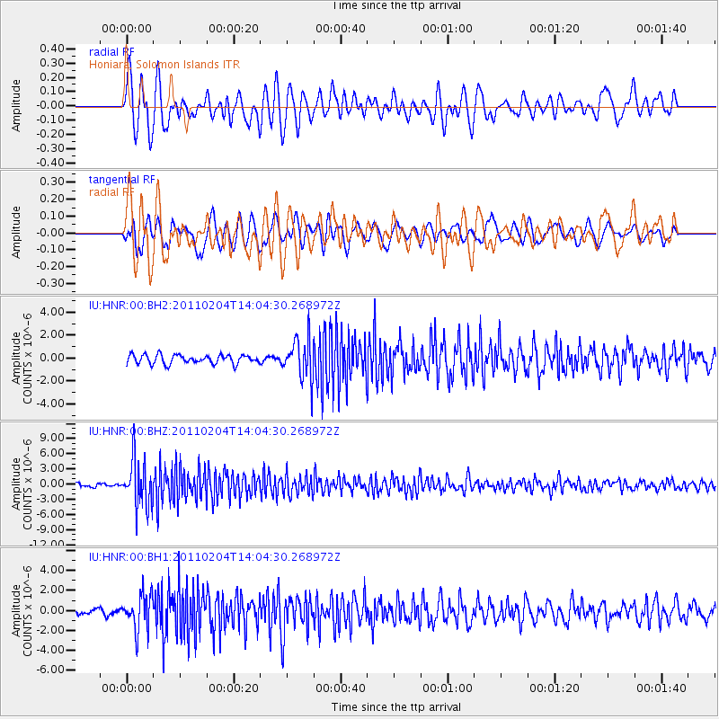
HNR Honiara, Solomon Islands - Earthquake Result Viewer
*The percent match for this event was below the threshold and hence no stack was calculated.
| Earthquake location: |
Myanmar-India Border Region |
| Earthquake latitude/longitude: |
24.6/94.7 |
| Earthquake time(UTC): |
2011/02/04 (035) 13:53:46 GMT |
| Earthquake Depth: |
85 km |
| Earthquake Magnitude: |
6.2 MW, 6.2 MW, 6.4 MB |
| Earthquake Catalog/Contributor: |
NEIC PDE/NEIC PDE-M |
|
| Network: |
IU Global Seismograph Network (GSN - IRIS/USGS) |
| Station: |
HNR Honiara, Solomon Islands |
| Lat/Lon: |
9.44 S/159.95 E |
| Elevation: |
100 m |
|
| Distance: |
72.0 deg |
| Az: |
109.611 deg |
| Baz: |
299.66 deg |
| Ray Param: |
$rayparam |
*The percent match for this event was below the threshold and hence was not used in the summary stack. |
|
| Radial Match: |
67.25425 % |
| Radial Bump: |
400 |
| Transverse Match: |
73.17572 % |
| Transverse Bump: |
400 |
| SOD ConfigId: |
617450 |
| Insert Time: |
2013-10-01 18:08:12.423 +0000 |
| GWidth: |
2.5 |
| Max Bumps: |
400 |
| Tol: |
0.001 |
|
Signal To Noise
| Channel | StoN | STA | LTA |
| IU:HNR:00:BHZ:20110204T14:04:30.268972Z | 15.217585 | 4.6146615E-6 | 3.0324532E-7 |
| IU:HNR:00:BH1:20110204T14:04:30.268972Z | 5.9063067 | 1.8002802E-6 | 3.0480643E-7 |
| IU:HNR:00:BH2:20110204T14:04:30.268972Z | 4.477927 | 1.7398478E-6 | 3.8853864E-7 |
| Arrivals |
| Ps | |
| PpPs | |
| PsPs/PpSs | |


