You are here: Home > Network List > II - Global Seismograph Network (GSN - IRIS/IDA) Stations List
> Station WRAB Tennant Creek, NT, Australia > Earthquake Result Viewer
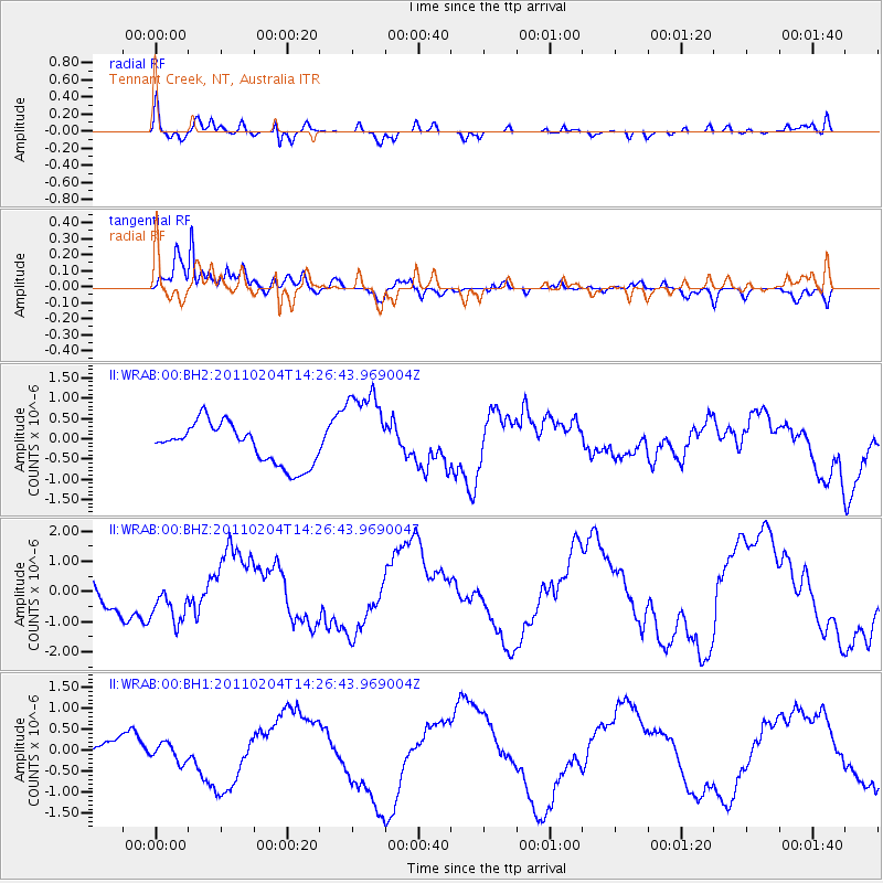
WRAB Tennant Creek, NT, Australia - Earthquake Result Viewer
*The percent match for this event was below the threshold and hence no stack was calculated.
| Earthquake location: |
Vanuatu Islands |
| Earthquake latitude/longitude: |
-14.2/166.5 |
| Earthquake time(UTC): |
2011/02/04 (035) 14:20:55 GMT |
| Earthquake Depth: |
10 km |
| Earthquake Magnitude: |
5.8 MB, 5.9 MW |
| Earthquake Catalog/Contributor: |
WHDF/NEIC |
|
| Network: |
II Global Seismograph Network (GSN - IRIS/IDA) |
| Station: |
WRAB Tennant Creek, NT, Australia |
| Lat/Lon: |
19.93 S/134.36 E |
| Elevation: |
366 m |
|
| Distance: |
31.2 deg |
| Az: |
254.933 deg |
| Baz: |
84.535 deg |
| Ray Param: |
$rayparam |
*The percent match for this event was below the threshold and hence was not used in the summary stack. |
|
| Radial Match: |
64.08901 % |
| Radial Bump: |
400 |
| Transverse Match: |
88.86692 % |
| Transverse Bump: |
378 |
| SOD ConfigId: |
617450 |
| Insert Time: |
2013-10-01 18:09:30.455 +0000 |
| GWidth: |
2.5 |
| Max Bumps: |
400 |
| Tol: |
0.001 |
|
Signal To Noise
| Channel | StoN | STA | LTA |
| II:WRAB:00:BHZ:20110204T14:26:43.969004Z | 1.200342 | 7.1086026E-7 | 5.9221475E-7 |
| II:WRAB:00:BH1:20110204T14:26:43.969004Z | 1.061822 | 2.146958E-7 | 2.0219565E-7 |
| II:WRAB:00:BH2:20110204T14:26:43.969004Z | 2.1659138 | 1.0774022E-6 | 4.974354E-7 |
| Arrivals |
| Ps | |
| PpPs | |
| PsPs/PpSs | |


