You are here: Home > Network List > II - Global Seismograph Network (GSN - IRIS/IDA) Stations List
> Station KAPI Kappang, Sulawesi, Indonesia > Earthquake Result Viewer
KAPI Kappang, Sulawesi, Indonesia - Earthquake Result Viewer
*The percent match for this event was below the threshold and hence no stack was calculated.
| Earthquake location: |
Near East Coast Of Honshu, Japan |
| Earthquake latitude/longitude: |
37.2/141.3 |
| Earthquake time(UTC): |
2011/02/10 (041) 13:03:02 GMT |
| Earthquake Depth: |
33 km |
| Earthquake Magnitude: |
5.5 MB |
| Earthquake Catalog/Contributor: |
NEIC PDE/NEIC PDE-M |
|
| Network: |
II Global Seismograph Network (GSN - IRIS/IDA) |
| Station: |
KAPI Kappang, Sulawesi, Indonesia |
| Lat/Lon: |
5.01 S/119.75 E |
| Elevation: |
300 m |
|
| Distance: |
46.5 deg |
| Az: |
210.257 deg |
| Baz: |
23.836 deg |
| Ray Param: |
$rayparam |
*The percent match for this event was below the threshold and hence was not used in the summary stack. |
|
| Radial Match: |
73.309875 % |
| Radial Bump: |
400 |
| Transverse Match: |
72.6539 % |
| Transverse Bump: |
400 |
| SOD ConfigId: |
617450 |
| Insert Time: |
2013-10-01 18:20:16.728 +0000 |
| GWidth: |
2.5 |
| Max Bumps: |
400 |
| Tol: |
0.001 |
|
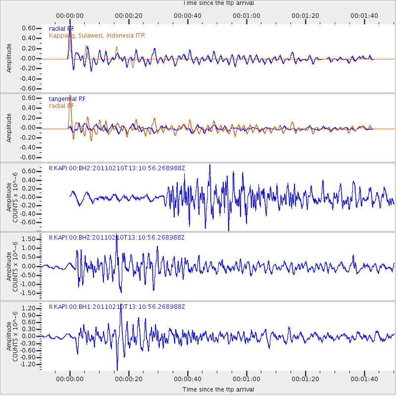
Signal To Noise
| Channel | StoN | STA | LTA |
| II:KAPI:00:BHZ:20110210T13:10:56.268988Z | 7.0352883 | 5.085778E-7 | 7.2289545E-8 |
| II:KAPI:00:BH1:20110210T13:10:56.268988Z | 4.2781954 | 2.4437276E-7 | 5.7120523E-8 |
| II:KAPI:00:BH2:20110210T13:10:56.268988Z | 1.7075793 | 1.0968744E-7 | 6.4235635E-8 |
| Arrivals |
| Ps | |
| PpPs | |
| PsPs/PpSs | |


