You are here: Home > Network List > II - Global Seismograph Network (GSN - IRIS/IDA) Stations List
> Station PALK Pallekele, Sri Lanka > Earthquake Result Viewer
PALK Pallekele, Sri Lanka - Earthquake Result Viewer
| Earthquake location: |
Celebes Sea |
| Earthquake latitude/longitude: |
4.2/123.0 |
| Earthquake time(UTC): |
2011/02/10 (041) 14:39:27 GMT |
| Earthquake Depth: |
523 km |
| Earthquake Magnitude: |
6.1 MB, 6.5 MW, 6.5 MW |
| Earthquake Catalog/Contributor: |
WHDF/NEIC |
|
| Network: |
II Global Seismograph Network (GSN - IRIS/IDA) |
| Station: |
PALK Pallekele, Sri Lanka |
| Lat/Lon: |
7.27 N/80.70 E |
| Elevation: |
460 m |
|
| Distance: |
42.2 deg |
| Az: |
276.165 deg |
| Baz: |
91.769 deg |
| Ray Param: |
0.07078944 |
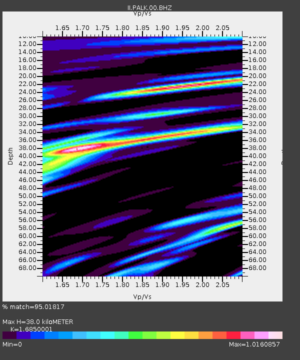
| Estimated Moho Depth: |
38.0 km |
| Estimated Crust Vp/Vs: |
1.69 |
| Assumed Crust Vp: |
6.545 km/s |
| Estimated Crust Vs: |
3.884 km/s |
| Estimated Crust Poisson's Ratio: |
0.23 |
|
| Radial Match: |
95.01817 % |
| Radial Bump: |
384 |
| Transverse Match: |
83.47296 % |
| Transverse Bump: |
400 |
| SOD ConfigId: |
617450 |
| Insert Time: |
2013-10-01 18:22:15.519 +0000 |
| GWidth: |
2.5 |
| Max Bumps: |
400 |
| Tol: |
0.001 |
|
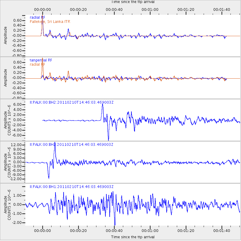
Signal To Noise
| Channel | StoN | STA | LTA |
| II:PALK:00:BHZ:20110210T14:46:03.469003Z | 24.658081 | 3.7834338E-6 | 1.5343586E-7 |
| II:PALK:00:BH1:20110210T14:46:03.469003Z | 2.8187938 | 3.4602778E-7 | 1.227574E-7 |
| II:PALK:00:BH2:20110210T14:46:03.469003Z | 19.677309 | 2.2178972E-6 | 1.1271344E-7 |
| Arrivals |
| Ps | 4.3 SECOND |
| PpPs | 15 SECOND |
| PsPs/PpSs | 19 SECOND |


