You are here: Home > Network List > II - Global Seismograph Network (GSN - IRIS/IDA) Stations List
> Station ABPO Ambohimpanompo, Madagascar > Earthquake Result Viewer
ABPO Ambohimpanompo, Madagascar - Earthquake Result Viewer
| Earthquake location: |
Celebes Sea |
| Earthquake latitude/longitude: |
4.1/123.0 |
| Earthquake time(UTC): |
2011/02/10 (041) 14:41:58 GMT |
| Earthquake Depth: |
525 km |
| Earthquake Magnitude: |
6.3 MB, 6.6 MW, 6.5 MW |
| Earthquake Catalog/Contributor: |
WHDF/NEIC |
|
| Network: |
II Global Seismograph Network (GSN - IRIS/IDA) |
| Station: |
ABPO Ambohimpanompo, Madagascar |
| Lat/Lon: |
19.02 S/47.23 E |
| Elevation: |
1528 m |
|
| Distance: |
78.0 deg |
| Az: |
249.689 deg |
| Baz: |
81.414 deg |
| Ray Param: |
0.04836323 |
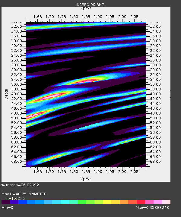
| Estimated Moho Depth: |
48.75 km |
| Estimated Crust Vp/Vs: |
1.63 |
| Assumed Crust Vp: |
6.642 km/s |
| Estimated Crust Vs: |
4.081 km/s |
| Estimated Crust Poisson's Ratio: |
0.20 |
|
| Radial Match: |
86.07692 % |
| Radial Bump: |
310 |
| Transverse Match: |
63.975487 % |
| Transverse Bump: |
400 |
| SOD ConfigId: |
617450 |
| Insert Time: |
2013-10-01 18:24:33.498 +0000 |
| GWidth: |
2.5 |
| Max Bumps: |
400 |
| Tol: |
0.001 |
|

Signal To Noise
| Channel | StoN | STA | LTA |
| II:ABPO:00:BHZ:20110210T14:52:31.518975Z | 4.8492885 | 3.868706E-6 | 7.977883E-7 |
| II:ABPO:00:BH1:20110210T14:52:31.518975Z | 1.4974716 | 2.8764183E-7 | 1.92085E-7 |
| II:ABPO:00:BH2:20110210T14:52:31.518975Z | 2.781639 | 1.208845E-6 | 4.3458007E-7 |
| Arrivals |
| Ps | 4.8 SECOND |
| PpPs | 19 SECOND |
| PsPs/PpSs | 23 SECOND |


