You are here: Home > Network List > II - Global Seismograph Network (GSN - IRIS/IDA) Stations List
> Station HOPE Hope Point, South Georgia Island > Earthquake Result Viewer
HOPE Hope Point, South Georgia Island - Earthquake Result Viewer
| Earthquake location: |
Near Coast Of Central Chile |
| Earthquake latitude/longitude: |
-36.5/-73.1 |
| Earthquake time(UTC): |
2011/02/11 (042) 20:05:30 GMT |
| Earthquake Depth: |
28 km |
| Earthquake Magnitude: |
6.0 MB, 6.8 MW, 6.8 MW |
| Earthquake Catalog/Contributor: |
WHDF/NEIC |
|
| Network: |
II Global Seismograph Network (GSN - IRIS/IDA) |
| Station: |
HOPE Hope Point, South Georgia Island |
| Lat/Lon: |
54.28 S/36.49 W |
| Elevation: |
20 m |
|
| Distance: |
30.8 deg |
| Az: |
136.94 deg |
| Baz: |
290.19 deg |
| Ray Param: |
0.079206064 |
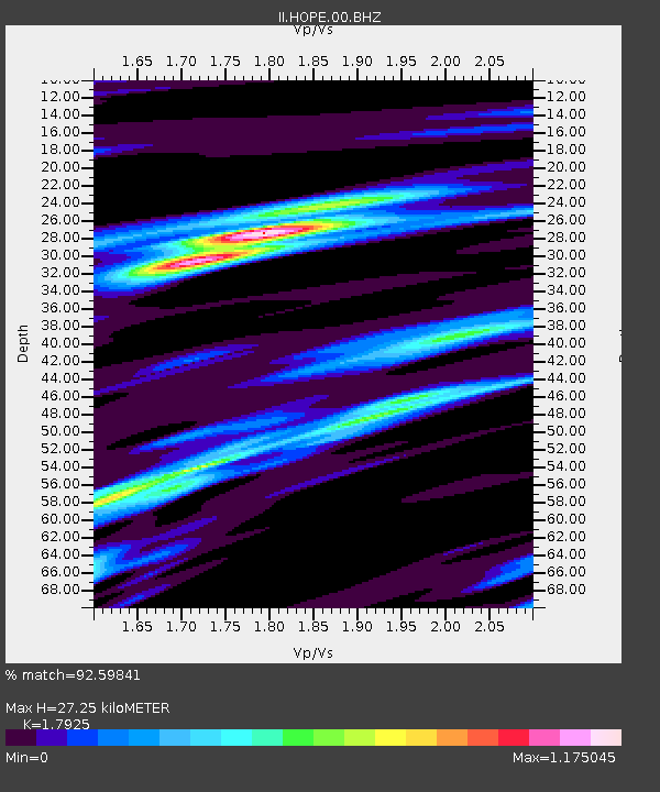
| Estimated Moho Depth: |
27.25 km |
| Estimated Crust Vp/Vs: |
1.79 |
| Assumed Crust Vp: |
4.73 km/s |
| Estimated Crust Vs: |
2.639 km/s |
| Estimated Crust Poisson's Ratio: |
0.27 |
|
| Radial Match: |
92.59841 % |
| Radial Bump: |
400 |
| Transverse Match: |
63.511288 % |
| Transverse Bump: |
400 |
| SOD ConfigId: |
617450 |
| Insert Time: |
2013-10-01 18:26:56.519 +0000 |
| GWidth: |
2.5 |
| Max Bumps: |
400 |
| Tol: |
0.001 |
|
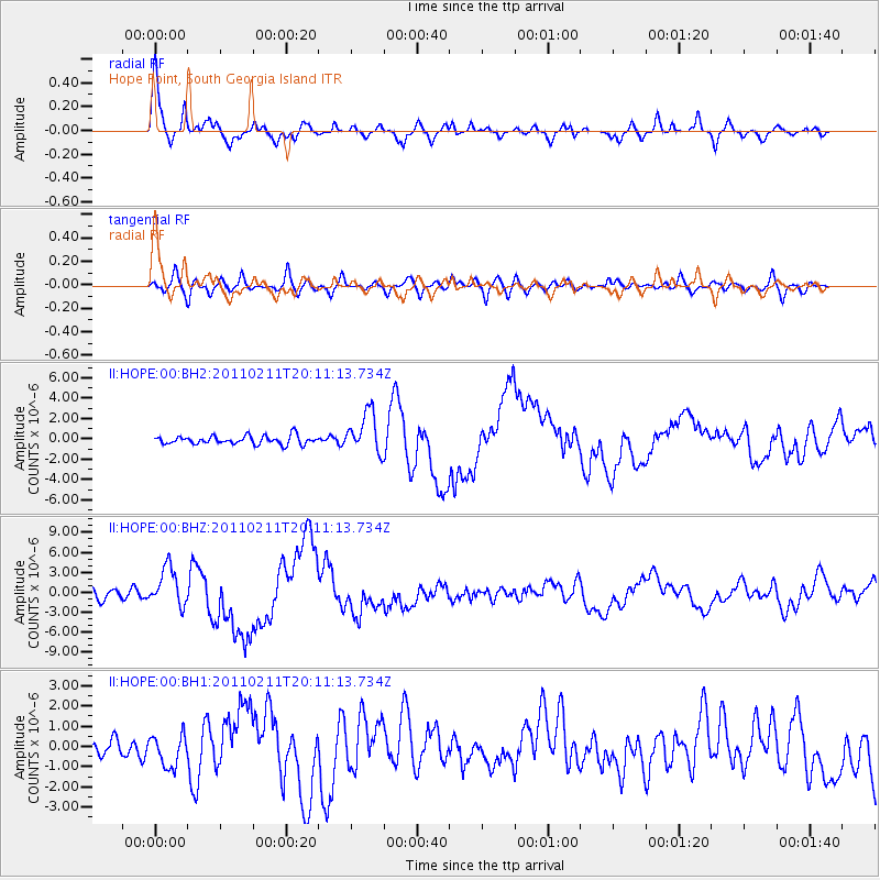
Signal To Noise
| Channel | StoN | STA | LTA |
| II:HOPE:00:BHZ:20110211T20:11:13.734Z | 4.709993 | 2.935323E-6 | 6.232118E-7 |
| II:HOPE:00:BH1:20110211T20:11:13.734Z | 1.4834806 | 8.127455E-7 | 5.478639E-7 |
| II:HOPE:00:BH2:20110211T20:11:13.734Z | 4.9018607 | 2.0258597E-6 | 4.1328383E-7 |
| Arrivals |
| Ps | 4.8 SECOND |
| PpPs | 15 SECOND |
| PsPs/PpSs | 20 SECOND |


