You are here: Home > Network List > IU - Global Seismograph Network (GSN - IRIS/USGS) Stations List
> Station TEIG Tepich, Yucatan, Mexico > Earthquake Result Viewer
TEIG Tepich, Yucatan, Mexico - Earthquake Result Viewer
| Earthquake location: |
Near Coast Of Central Chile |
| Earthquake latitude/longitude: |
-36.5/-73.1 |
| Earthquake time(UTC): |
2011/02/11 (042) 20:05:30 GMT |
| Earthquake Depth: |
28 km |
| Earthquake Magnitude: |
6.0 MB, 6.8 MW, 6.8 MW |
| Earthquake Catalog/Contributor: |
WHDF/NEIC |
|
| Network: |
IU Global Seismograph Network (GSN - IRIS/USGS) |
| Station: |
TEIG Tepich, Yucatan, Mexico |
| Lat/Lon: |
20.23 N/88.28 W |
| Elevation: |
40 m |
|
| Distance: |
58.2 deg |
| Az: |
343.211 deg |
| Baz: |
165.645 deg |
| Ray Param: |
0.062966906 |
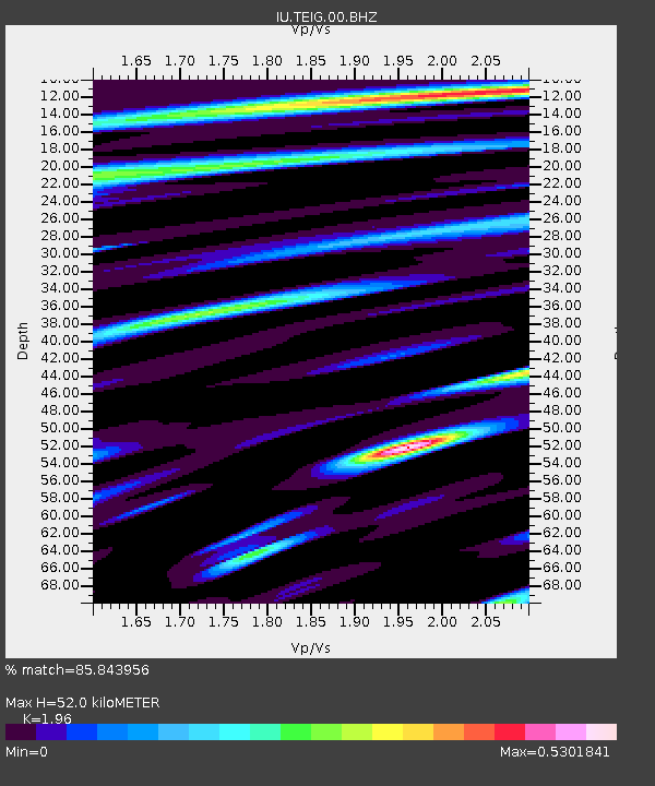
| Estimated Moho Depth: |
52.0 km |
| Estimated Crust Vp/Vs: |
1.96 |
| Assumed Crust Vp: |
5.817 km/s |
| Estimated Crust Vs: |
2.968 km/s |
| Estimated Crust Poisson's Ratio: |
0.32 |
|
| Radial Match: |
85.843956 % |
| Radial Bump: |
400 |
| Transverse Match: |
85.80923 % |
| Transverse Bump: |
400 |
| SOD ConfigId: |
617450 |
| Insert Time: |
2013-10-01 18:27:21.459 +0000 |
| GWidth: |
2.5 |
| Max Bumps: |
400 |
| Tol: |
0.001 |
|

Signal To Noise
| Channel | StoN | STA | LTA |
| IU:TEIG:00:BHZ:20110211T20:14:51.617026Z | 2.4368763 | 1.10471E-6 | 4.5333036E-7 |
| IU:TEIG:00:BH1:20110211T20:14:51.617026Z | 0.91111004 | 2.3834328E-8 | 2.615966E-8 |
| IU:TEIG:00:BH2:20110211T20:14:51.617026Z | 1.6306208 | 5.769041E-7 | 3.5379415E-7 |
| Arrivals |
| Ps | 8.9 SECOND |
| PpPs | 26 SECOND |
| PsPs/PpSs | 34 SECOND |


