You are here: Home > Network List > II - Global Seismograph Network (GSN - IRIS/IDA) Stations List
> Station HOPE Hope Point, South Georgia Island > Earthquake Result Viewer
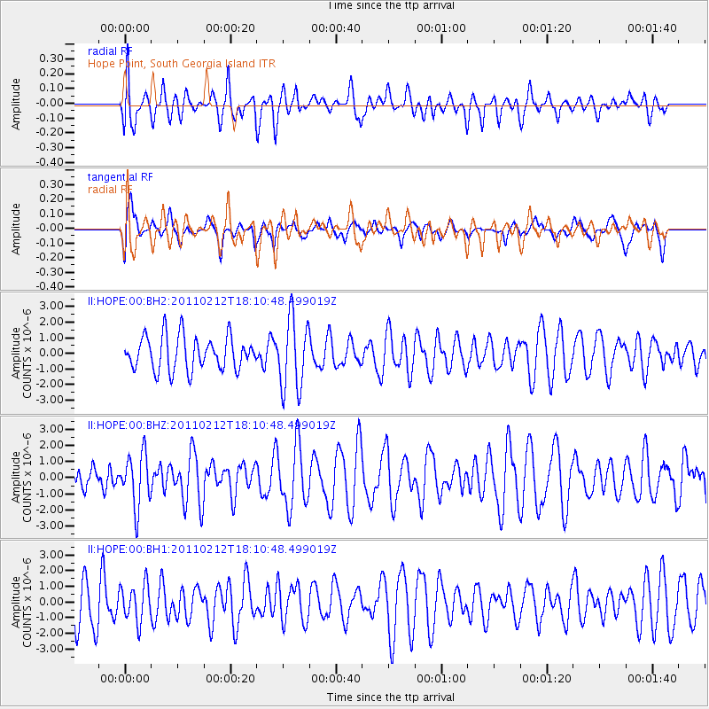
HOPE Hope Point, South Georgia Island - Earthquake Result Viewer
*The percent match for this event was below the threshold and hence no stack was calculated.
| Earthquake location: |
Tonga Islands |
| Earthquake latitude/longitude: |
-20.9/-175.7 |
| Earthquake time(UTC): |
2011/02/12 (043) 17:57:56 GMT |
| Earthquake Depth: |
90 km |
| Earthquake Magnitude: |
6.0 MB, 6.1 MW, 6.1 MW |
| Earthquake Catalog/Contributor: |
WHDF/NEIC |
|
| Network: |
II Global Seismograph Network (GSN - IRIS/IDA) |
| Station: |
HOPE Hope Point, South Georgia Island |
| Lat/Lon: |
54.28 S/36.49 W |
| Elevation: |
20 m |
|
| Distance: |
97.3 deg |
| Az: |
157.268 deg |
| Baz: |
218.043 deg |
| Ray Param: |
$rayparam |
*The percent match for this event was below the threshold and hence was not used in the summary stack. |
|
| Radial Match: |
51.201977 % |
| Radial Bump: |
400 |
| Transverse Match: |
51.07833 % |
| Transverse Bump: |
400 |
| SOD ConfigId: |
617450 |
| Insert Time: |
2013-10-01 18:36:49.574 +0000 |
| GWidth: |
2.5 |
| Max Bumps: |
400 |
| Tol: |
0.001 |
|
Signal To Noise
| Channel | StoN | STA | LTA |
| II:HOPE:00:BHZ:20110212T18:10:48.499019Z | 1.702798 | 1.6635184E-6 | 9.769323E-7 |
| II:HOPE:00:BH1:20110212T18:10:48.499019Z | 1.0749316 | 1.1810844E-6 | 1.098753E-6 |
| II:HOPE:00:BH2:20110212T18:10:48.499019Z | 2.12676 | 2.2973074E-6 | 1.0801912E-6 |
| Arrivals |
| Ps | |
| PpPs | |
| PsPs/PpSs | |


