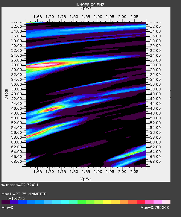
HOPE Hope Point, South Georgia Island - Earthquake Result Viewer
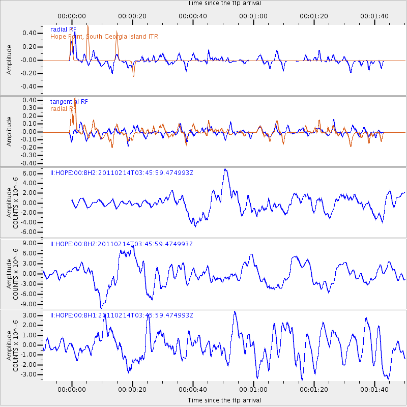
Earthquake location: Near Coast Of Central Chile
Earthquake latitude/longitude: -35.4/-72.8
Earthquake time(UTC): 2011/02/14 (045) 03:40:09 GMT
Earthquake Depth: 21 km
Earthquake Magnitude: 6.6 MW, 5.9 MB, 6.6 MS, 6.7 MW
Earthquake Catalog/Contributor: NEIC PDE/NEIC PDE-M
Network: II Global Seismograph Network (GSN - IRIS/IDA)
Station: HOPE Hope Point, South Georgia Island
Lat/Lon: 54.28 S/36.49 W
Elevation: 20 m
Distance: 31.5 deg
Az: 138.276 deg
Baz: 291.95 deg
Ray Param: 0.079038456
Estimated Moho Depth: 27.75 km
Estimated Crust Vp/Vs: 1.68
Assumed Crust Vp: 4.73 km/s
Estimated Crust Vs: 2.82 km/s
Estimated Crust Poisson's Ratio: 0.22
Radial Match: 87.72411 %
Radial Bump: 368
Transverse Match: 60.011963 %
Transverse Bump: 400
SOD ConfigId: 617450
Insert Time: 2013-10-01 18:43:20.975 +0000
GWidth: 2.5
Max Bumps: 400
Tol: 0.001

Signal To Noise

ChannelStoNSTALTA
II:HOPE:00:BHZ:20110214T03:45:59.474993Z2.7742921.9277672E-66.9486816E-7
II:HOPE:00:BH1:20110214T03:45:59.474993Z1.49119576.7177774E-74.5049603E-7
II:HOPE:00:BH2:20110214T03:45:59.474993Z2.50533941.2841912E-65.125817E-7
Arrivals
Ps4.2 SECOND
PpPs15 SECOND
PsPs/PpSs19 SECOND