You are here: Home > Network List > IU - Global Seismograph Network (GSN - IRIS/USGS) Stations List
> Station HNR Honiara, Solomon Islands > Earthquake Result Viewer
HNR Honiara, Solomon Islands - Earthquake Result Viewer
| Earthquake location: |
Sulawesi, Indonesia |
| Earthquake latitude/longitude: |
-2.5/121.5 |
| Earthquake time(UTC): |
2011/02/15 (046) 13:33:53 GMT |
| Earthquake Depth: |
16 km |
| Earthquake Magnitude: |
6.1 MW, 5.8 MS, 5.9 MB, 6.1 MW |
| Earthquake Catalog/Contributor: |
NEIC PDE/NEIC PDE-M |
|
| Network: |
IU Global Seismograph Network (GSN - IRIS/USGS) |
| Station: |
HNR Honiara, Solomon Islands |
| Lat/Lon: |
9.44 S/159.95 E |
| Elevation: |
100 m |
|
| Distance: |
38.8 deg |
| Az: |
101.901 deg |
| Baz: |
277.766 deg |
| Ray Param: |
0.07531177 |
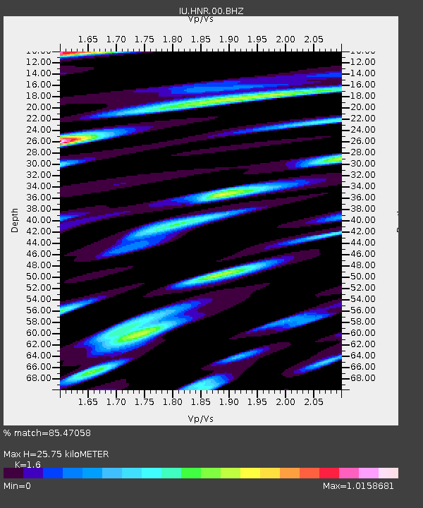
| Estimated Moho Depth: |
25.75 km |
| Estimated Crust Vp/Vs: |
1.60 |
| Assumed Crust Vp: |
6.183 km/s |
| Estimated Crust Vs: |
3.864 km/s |
| Estimated Crust Poisson's Ratio: |
0.18 |
|
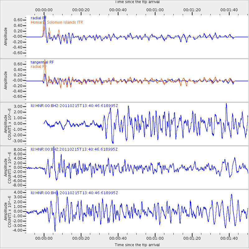
| Radial Match: |
85.47058 % |
| Radial Bump: |
400 |
| Transverse Match: |
81.45082 % |
| Transverse Bump: |
400 |
| SOD ConfigId: |
617450 |
| Insert Time: |
2013-10-01 18:46:29.519 +0000 |
| GWidth: |
2.5 |
| Max Bumps: |
400 |
| Tol: |
0.001 |
|
Signal To Noise
| Channel | StoN | STA | LTA |
| IU:HNR:00:BHZ:20110215T13:40:46.618995Z | 8.445995 | 1.8248777E-6 | 2.1606425E-7 |
| IU:HNR:00:BH1:20110215T13:40:46.618995Z | 3.790293 | 1.0423773E-6 | 2.7501233E-7 |
| IU:HNR:00:BH2:20110215T13:40:46.618995Z | 2.9481876 | 9.807258E-7 | 3.326538E-7 |
| Arrivals |
| Ps | 2.7 SECOND |
| PpPs | 10 SECOND |
| PsPs/PpSs | 13 SECOND |


