You are here: Home > Network List > II - Global Seismograph Network (GSN - IRIS/IDA) Stations List
> Station AAK Ala Archa, Kyrgyzstan > Earthquake Result Viewer
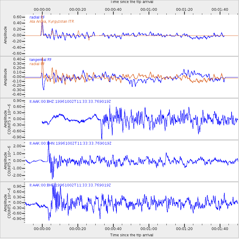
AAK Ala Archa, Kyrgyzstan - Earthquake Result Viewer
*The percent match for this event was below the threshold and hence no stack was calculated.
| Earthquake location: |
Kuril Islands |
| Earthquake latitude/longitude: |
45.1/151.2 |
| Earthquake time(UTC): |
1996/10/02 (276) 11:24:48 GMT |
| Earthquake Depth: |
33 km |
| Earthquake Magnitude: |
6.1 MB, 5.4 MS, 6.0 UNKNOWN, 6.0 MW |
| Earthquake Catalog/Contributor: |
WHDF/NEIC |
|
| Network: |
II Global Seismograph Network (GSN - IRIS/IDA) |
| Station: |
AAK Ala Archa, Kyrgyzstan |
| Lat/Lon: |
42.64 N/74.49 E |
| Elevation: |
1645 m |
|
| Distance: |
53.3 deg |
| Az: |
296.474 deg |
| Baz: |
59.168 deg |
| Ray Param: |
$rayparam |
*The percent match for this event was below the threshold and hence was not used in the summary stack. |
|
| Radial Match: |
60.588886 % |
| Radial Bump: |
400 |
| Transverse Match: |
56.644154 % |
| Transverse Bump: |
400 |
| SOD ConfigId: |
4480 |
| Insert Time: |
2010-03-01 15:45:29.837 +0000 |
| GWidth: |
2.5 |
| Max Bumps: |
400 |
| Tol: |
0.001 |
|
Signal To Noise
| Channel | StoN | STA | LTA |
| II:AAK:00:BHN:19961002T11:33:33.769019Z | 7.560132 | 8.178441E-7 | 1.08178554E-7 |
| II:AAK:00:BHE:19961002T11:33:33.769019Z | 2.582217 | 5.156446E-7 | 1.9969066E-7 |
| II:AAK:00:BHZ:19961002T11:33:33.769019Z | 2.3362188 | 2.9714E-7 | 1.2718841E-7 |
| Arrivals |
| Ps | |
| PpPs | |
| PsPs/PpSs | |


