You are here: Home > Network List > IU - Global Seismograph Network (GSN - IRIS/USGS) Stations List
> Station MAKZ Makanchi, Kazakhstan > Earthquake Result Viewer
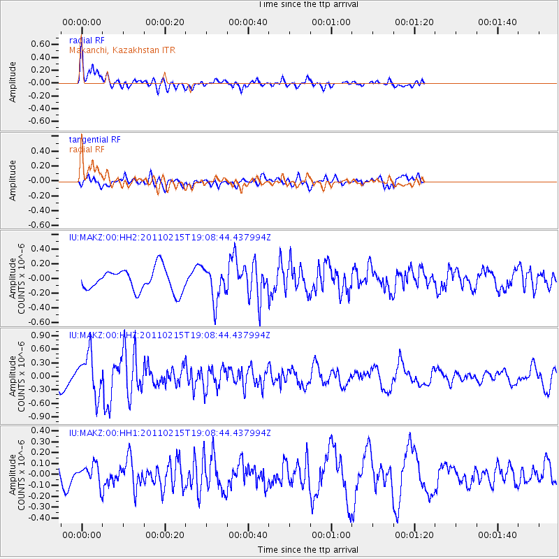
MAKZ Makanchi, Kazakhstan - Earthquake Result Viewer
*The percent match for this event was below the threshold and hence no stack was calculated.
| Earthquake location: |
Off East Coast Of Honshu, Japan |
| Earthquake latitude/longitude: |
38.3/143.2 |
| Earthquake time(UTC): |
2011/02/15 (046) 19:01:03 GMT |
| Earthquake Depth: |
26 km |
| Earthquake Magnitude: |
5.5 MW |
| Earthquake Catalog/Contributor: |
NEIC PDE/NEIC PDE-M |
|
| Network: |
IU Global Seismograph Network (GSN - IRIS/USGS) |
| Station: |
MAKZ Makanchi, Kazakhstan |
| Lat/Lon: |
46.81 N/81.98 E |
| Elevation: |
600 m |
|
| Distance: |
44.8 deg |
| Az: |
301.39 deg |
| Baz: |
77.83 deg |
| Ray Param: |
$rayparam |
*The percent match for this event was below the threshold and hence was not used in the summary stack. |
|
| Radial Match: |
70.46932 % |
| Radial Bump: |
400 |
| Transverse Match: |
78.47417 % |
| Transverse Bump: |
400 |
| SOD ConfigId: |
617450 |
| Insert Time: |
2013-10-01 18:48:04.807 +0000 |
| GWidth: |
2.5 |
| Max Bumps: |
400 |
| Tol: |
0.001 |
|
Signal To Noise
| Channel | StoN | STA | LTA |
| IU:MAKZ:00:HHZ:20110215T19:08:44.437994Z | 2.5840347 | 4.715643E-7 | 1.8249149E-7 |
| IU:MAKZ:00:HH1:20110215T19:08:44.437994Z | 1.0821348 | 8.895034E-8 | 8.219894E-8 |
| IU:MAKZ:00:HH2:20110215T19:08:44.437994Z | 1.5020009 | 2.2979383E-7 | 1.529918E-7 |
| Arrivals |
| Ps | |
| PpPs | |
| PsPs/PpSs | |


