You are here: Home > Network List > IU - Global Seismograph Network (GSN - IRIS/USGS) Stations List
> Station HNR Honiara, Solomon Islands > Earthquake Result Viewer
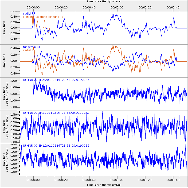
HNR Honiara, Solomon Islands - Earthquake Result Viewer
*The percent match for this event was below the threshold and hence no stack was calculated.
| Earthquake location: |
Ryukyu Islands, Japan |
| Earthquake latitude/longitude: |
25.9/128.3 |
| Earthquake time(UTC): |
2011/02/16 (047) 23:45:10 GMT |
| Earthquake Depth: |
6.9 km |
| Earthquake Magnitude: |
5.5 MB |
| Earthquake Catalog/Contributor: |
NEIC PDE/NEIC PDE-M |
|
| Network: |
IU Global Seismograph Network (GSN - IRIS/USGS) |
| Station: |
HNR Honiara, Solomon Islands |
| Lat/Lon: |
9.44 S/159.95 E |
| Elevation: |
100 m |
|
| Distance: |
46.7 deg |
| Az: |
134.65 deg |
| Baz: |
319.503 deg |
| Ray Param: |
$rayparam |
*The percent match for this event was below the threshold and hence was not used in the summary stack. |
|
| Radial Match: |
40.744614 % |
| Radial Bump: |
400 |
| Transverse Match: |
35.252384 % |
| Transverse Bump: |
400 |
| SOD ConfigId: |
617450 |
| Insert Time: |
2013-10-01 18:51:55.183 +0000 |
| GWidth: |
2.5 |
| Max Bumps: |
400 |
| Tol: |
0.001 |
|
Signal To Noise
| Channel | StoN | STA | LTA |
| IU:HNR:00:BHZ:20110216T23:53:09.019008Z | 1.2922693 | 6.865842E-7 | 5.3130117E-7 |
| IU:HNR:00:BH1:20110216T23:53:09.019008Z | 1.0471206 | 7.2461535E-7 | 6.9200763E-7 |
| IU:HNR:00:BH2:20110216T23:53:09.019008Z | 0.89855707 | 6.6624364E-7 | 7.414595E-7 |
| Arrivals |
| Ps | |
| PpPs | |
| PsPs/PpSs | |


