You are here: Home > Network List > IU - Global Seismograph Network (GSN - IRIS/USGS) Stations List
> Station JOHN Johnston Island, USA > Earthquake Result Viewer
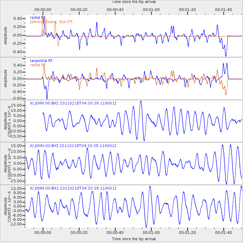
JOHN Johnston Island, USA - Earthquake Result Viewer
*The percent match for this event was below the threshold and hence no stack was calculated.
| Earthquake location: |
New Ireland Region, P.N.G. |
| Earthquake latitude/longitude: |
-4.6/153.2 |
| Earthquake time(UTC): |
2011/02/18 (049) 04:23:18 GMT |
| Earthquake Depth: |
58 km |
| Earthquake Magnitude: |
5.5 MW, 5.5 MW |
| Earthquake Catalog/Contributor: |
NEIC PDE/NEIC PDE-M |
|
| Network: |
IU Global Seismograph Network (GSN - IRIS/USGS) |
| Station: |
JOHN Johnston Island, USA |
| Lat/Lon: |
16.73 N/169.53 W |
| Elevation: |
2.0 m |
|
| Distance: |
42.5 deg |
| Az: |
59.209 deg |
| Baz: |
243.337 deg |
| Ray Param: |
$rayparam |
*The percent match for this event was below the threshold and hence was not used in the summary stack. |
|
| Radial Match: |
55.812294 % |
| Radial Bump: |
400 |
| Transverse Match: |
48.16659 % |
| Transverse Bump: |
400 |
| SOD ConfigId: |
617450 |
| Insert Time: |
2013-10-01 18:55:34.443 +0000 |
| GWidth: |
2.5 |
| Max Bumps: |
400 |
| Tol: |
0.001 |
|
Signal To Noise
| Channel | StoN | STA | LTA |
| IU:JOHN:00:BHZ:20110218T04:30:38.119001Z | 1.7738749 | 8.338071E-6 | 4.700484E-6 |
| IU:JOHN:00:BH1:20110218T04:30:38.119001Z | 0.9562039 | 5.6598906E-6 | 5.919125E-6 |
| IU:JOHN:00:BH2:20110218T04:30:38.119001Z | 0.49483064 | 2.350314E-6 | 4.749734E-6 |
| Arrivals |
| Ps | |
| PpPs | |
| PsPs/PpSs | |


