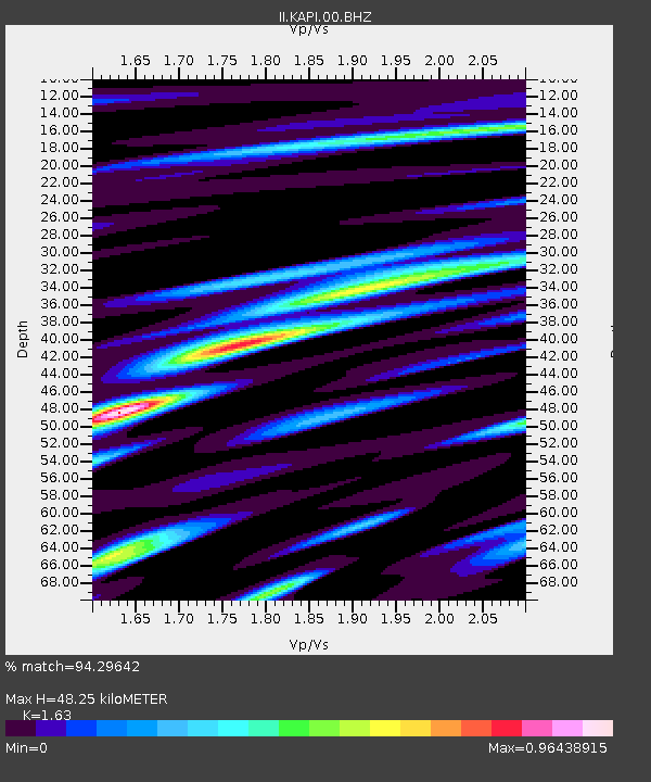
KAPI Kappang, Sulawesi, Indonesia - Earthquake Result Viewer

Earthquake location: South Island, New Zealand
Earthquake latitude/longitude: -43.6/172.7
Earthquake time(UTC): 2011/02/21 (052) 23:51:42 GMT
Earthquake Depth: 5.9 km
Earthquake Magnitude: 6.1 MW, 6.1 MB, 6.1 MW, 6.3 MS
Earthquake Catalog/Contributor: NEIC PDE/NEIC PDE-M
Network: II Global Seismograph Network (GSN - IRIS/IDA)
Station: KAPI Kappang, Sulawesi, Indonesia
Lat/Lon: 5.01 S/119.75 E
Elevation: 300 m
Distance: 60.3 deg
Az: 293.732 deg
Baz: 138.106 deg
Ray Param: 0.061658684
Estimated Moho Depth: 48.25 km
Estimated Crust Vp/Vs: 1.63
Assumed Crust Vp: 6.343 km/s
Estimated Crust Vs: 3.892 km/s
Estimated Crust Poisson's Ratio: 0.20
Radial Match: 94.29642 %
Radial Bump: 400
Transverse Match: 92.01627 %
Transverse Bump: 400
SOD ConfigId: 617450
Insert Time: 2013-10-01 19:09:27.535 +0000
GWidth: 2.5
Max Bumps: 400
Tol: 0.001

Signal To Noise

ChannelStoNSTALTA
II:KAPI:00:BHZ:20110222T00:01:20.368982Z31.605832.9878813E-69.4535764E-8
II:KAPI:00:BH1:20110222T00:01:20.368982Z13.7670731.1111557E-68.071111E-8
II:KAPI:00:BH2:20110222T00:01:20.368982Z10.6578369.716985E-79.117221E-8
Arrivals
Ps5.0 SECOND
PpPs19 SECOND
PsPs/PpSs24 SECOND