You are here: Home > Network List > IU - Global Seismograph Network (GSN - IRIS/USGS) Stations List
> Station HNR Honiara, Solomon Islands > Earthquake Result Viewer
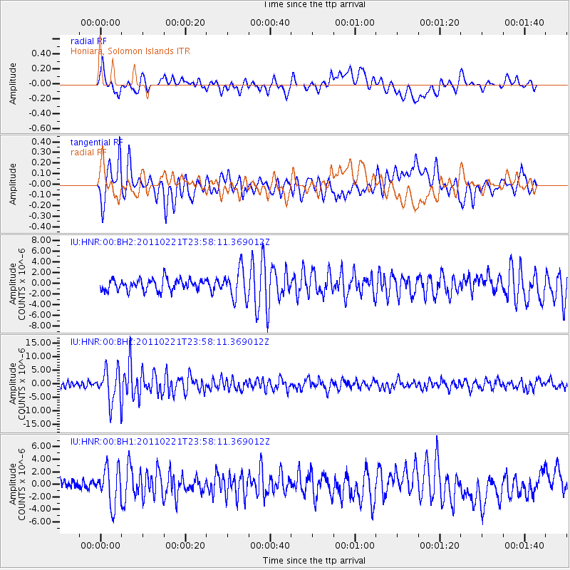
HNR Honiara, Solomon Islands - Earthquake Result Viewer
*The percent match for this event was below the threshold and hence no stack was calculated.
| Earthquake location: |
South Island, New Zealand |
| Earthquake latitude/longitude: |
-43.6/172.7 |
| Earthquake time(UTC): |
2011/02/21 (052) 23:51:42 GMT |
| Earthquake Depth: |
5.9 km |
| Earthquake Magnitude: |
6.1 MW, 6.1 MB, 6.1 MW, 6.3 MS |
| Earthquake Catalog/Contributor: |
NEIC PDE/NEIC PDE-M |
|
| Network: |
IU Global Seismograph Network (GSN - IRIS/USGS) |
| Station: |
HNR Honiara, Solomon Islands |
| Lat/Lon: |
9.44 S/159.95 E |
| Elevation: |
100 m |
|
| Distance: |
35.8 deg |
| Az: |
338.166 deg |
| Baz: |
164.102 deg |
| Ray Param: |
$rayparam |
*The percent match for this event was below the threshold and hence was not used in the summary stack. |
|
| Radial Match: |
49.321934 % |
| Radial Bump: |
400 |
| Transverse Match: |
71.59951 % |
| Transverse Bump: |
400 |
| SOD ConfigId: |
617450 |
| Insert Time: |
2013-10-01 19:09:40.453 +0000 |
| GWidth: |
2.5 |
| Max Bumps: |
400 |
| Tol: |
0.001 |
|
Signal To Noise
| Channel | StoN | STA | LTA |
| IU:HNR:00:BHZ:20110221T23:58:11.369012Z | 6.8338566 | 6.3818175E-6 | 9.33853E-7 |
| IU:HNR:00:BH1:20110221T23:58:11.369012Z | 4.1359324 | 3.0223764E-6 | 7.3076063E-7 |
| IU:HNR:00:BH2:20110221T23:58:11.369012Z | 2.808254 | 2.8799927E-6 | 1.0255457E-6 |
| Arrivals |
| Ps | |
| PpPs | |
| PsPs/PpSs | |


