You are here: Home > Network List > II - Global Seismograph Network (GSN - IRIS/IDA) Stations List
> Station KAPI Kappang, Sulawesi, Indonesia > Earthquake Result Viewer
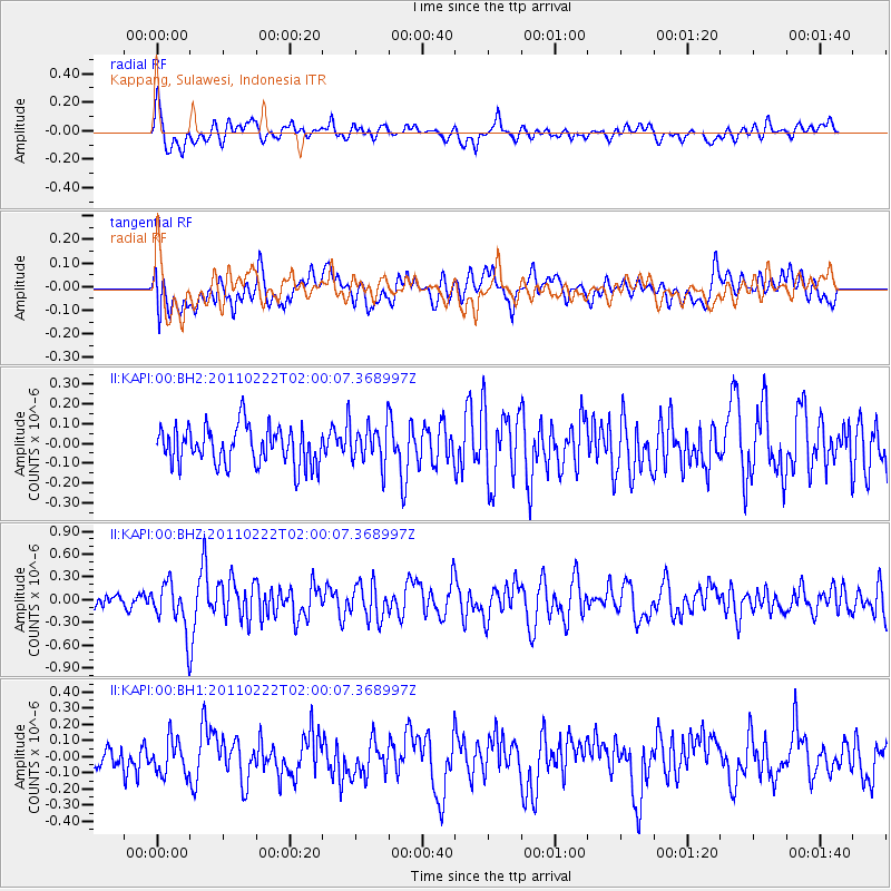
KAPI Kappang, Sulawesi, Indonesia - Earthquake Result Viewer
*The percent match for this event was below the threshold and hence no stack was calculated.
| Earthquake location: |
South Island, New Zealand |
| Earthquake latitude/longitude: |
-43.6/172.6 |
| Earthquake time(UTC): |
2011/02/22 (053) 01:50:29 GMT |
| Earthquake Depth: |
6.6 km |
| Earthquake Magnitude: |
5.6 MW, 5.5 MB, 5.5 MS, 5.6 MW |
| Earthquake Catalog/Contributor: |
NEIC PDE/NEIC PDE-M |
|
| Network: |
II Global Seismograph Network (GSN - IRIS/IDA) |
| Station: |
KAPI Kappang, Sulawesi, Indonesia |
| Lat/Lon: |
5.01 S/119.75 E |
| Elevation: |
300 m |
|
| Distance: |
60.2 deg |
| Az: |
293.791 deg |
| Baz: |
138.142 deg |
| Ray Param: |
$rayparam |
*The percent match for this event was below the threshold and hence was not used in the summary stack. |
|
| Radial Match: |
70.72438 % |
| Radial Bump: |
400 |
| Transverse Match: |
56.06203 % |
| Transverse Bump: |
400 |
| SOD ConfigId: |
617450 |
| Insert Time: |
2013-10-01 19:12:21.826 +0000 |
| GWidth: |
2.5 |
| Max Bumps: |
400 |
| Tol: |
0.001 |
|
Signal To Noise
| Channel | StoN | STA | LTA |
| II:KAPI:00:BHZ:20110222T02:00:07.368997Z | 2.565957 | 3.1129815E-7 | 1.2131852E-7 |
| II:KAPI:00:BH1:20110222T02:00:07.368997Z | 1.0730639 | 1.06601256E-7 | 9.9342884E-8 |
| II:KAPI:00:BH2:20110222T02:00:07.368997Z | 1.0471176 | 1.0079659E-7 | 9.6261005E-8 |
| Arrivals |
| Ps | |
| PpPs | |
| PsPs/PpSs | |


