You are here: Home > Network List > II - Global Seismograph Network (GSN - IRIS/IDA) Stations List
> Station WRAB Tennant Creek, NT, Australia > Earthquake Result Viewer
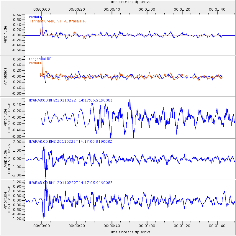
WRAB Tennant Creek, NT, Australia - Earthquake Result Viewer
*The percent match for this event was below the threshold and hence no stack was calculated.
| Earthquake location: |
Volcano Islands, Japan Region |
| Earthquake latitude/longitude: |
22.1/143.8 |
| Earthquake time(UTC): |
2011/02/22 (053) 14:09:50 GMT |
| Earthquake Depth: |
113 km |
| Earthquake Magnitude: |
5.5 MW, 5.5 MW, 5.6 MB |
| Earthquake Catalog/Contributor: |
NEIC PDE/NEIC PDE-M |
|
| Network: |
II Global Seismograph Network (GSN - IRIS/IDA) |
| Station: |
WRAB Tennant Creek, NT, Australia |
| Lat/Lon: |
19.93 S/134.36 E |
| Elevation: |
366 m |
|
| Distance: |
42.8 deg |
| Az: |
193.185 deg |
| Baz: |
12.993 deg |
| Ray Param: |
$rayparam |
*The percent match for this event was below the threshold and hence was not used in the summary stack. |
|
| Radial Match: |
73.48554 % |
| Radial Bump: |
400 |
| Transverse Match: |
51.286716 % |
| Transverse Bump: |
400 |
| SOD ConfigId: |
617450 |
| Insert Time: |
2013-10-01 19:13:45.793 +0000 |
| GWidth: |
2.5 |
| Max Bumps: |
400 |
| Tol: |
0.001 |
|
Signal To Noise
| Channel | StoN | STA | LTA |
| II:WRAB:00:BHZ:20110222T14:17:06.919008Z | 5.9950304 | 8.835594E-7 | 1.4738197E-7 |
| II:WRAB:00:BH1:20110222T14:17:06.919008Z | 5.461702 | 5.9698687E-7 | 1.0930418E-7 |
| II:WRAB:00:BH2:20110222T14:17:06.919008Z | 2.090387 | 2.7211695E-7 | 1.301754E-7 |
| Arrivals |
| Ps | |
| PpPs | |
| PsPs/PpSs | |


